About me
Dear Visitors, my name is Igor Gaspar, I am a mechanical engineer, but Geography has always been my favorite subject. Together with my family, I built this site based on my offline tools for city analyzing, so these main geodata for a city can be found on one place and they are now available online for everybody for free.
What is your favorite city geodata type on this site? My contact can be found on the bottom of "Terms of use" page.
About geolist.org + help
What is latitude and longitude?
Latitude is geographical coordinate and it can have value from -90° (South Pole), over the equator (0°) to the North pole (+90°).
Longitude is a second geographical coordinate number from -180° to +180°. Prime meridian (0°Longitude) is based on the meridian of the Royal Observatory, Greenwich.
These numbers may be specific in decimal format (example: -66.56356°) or in degrees, minutes and seconds (example: 66° 33' 48.82" South).
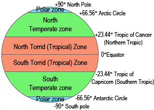
 Geographic Zones explained:
- North frigid zone: Zone between the Arctic Circle +66.56356° and the North Pole +90°.
- North temperate zone is located between the Tropic of Cancer +23.43672° and the Arctic Circle +66.56356°.
- Torrid zone: Can be found between the Tropic of Cancer +23.43672° and the Tropic of Capricorn -23.43672°.
- South temperate zone: Land area between the Tropic of Capricorn -23.43672° and the Antarctic Circle -66.56356°.
- South frigid zone: Area from Antarctic Circle -66.56356° and the South Pole -90°.
Read more about geograhical zones on Wikipedia.
Units
All length units (elevation, distances) are stored in metric format. Conversion into imperial values is calculated according conversion numbers meter to foot and km to miles.
