Cities geodata
Welcome to geolist.org, the site where you can find geographical data for cities like latitude, longitude (GPS) coordinates, nearby cities, administrative divisions, time zones, distances from equator and poles, estimated population, elevation. On map you can find maximal and minimal lat/long values for edges. You can find used sources at the bottom of each page. First step is to find a country.
Quick example:
Random countries: • Russia • Australia • France
Random cities:
• Brisbane • Düsseldorf • Sheffield • Stockholm • Taipei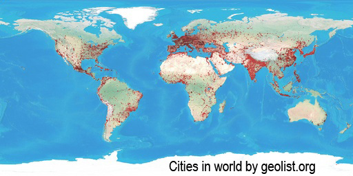
Download the above map in big (20,000x10,000 pixel) resolution: Cities in World (JPG, 36 MByte!)
Map is generated using coordinates from every city in our database. Smallest cities has circle of 3 pixel diameter, largest locations have 15 pixel circles, according to population.
