Peshkopi geodata
Peshkopi (Dibër) is a seat of a first-order administrative division; located in Albania in Europe/Tirane (GMT+2) time zone. With population of 14,848 people, there are 22 cities with bigger population in this country. Compared to other cities in Albania, 78.6% of cities are located further ↓South; 85.6% of cities are located further ←West and 74.6% of cities have lower elevation than Peshkopi. Note1


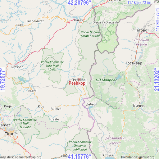
Peshkopi GPS coordinates[2]
41° 41' 6" North, 20° 25' 44.004" East
| Map corner | latitude | longitude |
|---|---|---|
| Upper-left | 42.20796°, | 19.72577° |
| Center: | 41.685°, | 20.42889° |
| Lower-right: | 41.15776°, | 21.13202° |
| Map W x H: | 116.8×116.8 km | = 72.6×72.6mi |
| max Lat: | 42.45139° ⇑21.4% North |
| Peshkopi: | 41.685° |
| min Lat: | ⇓78.6% South 39.65889° |
| min Long | Peshkopi | max Long |
| 19.40556° | 20.42889° | 20.99° |
| W 85.6%⇐ | ⇒14.4% E |
Elevation
Elevation of Peshkopi is 660 m = 2165 ft, and this is 285.4 m = 936 ft above average elevation for this country.
| Max E: |
1352 m = 4436 ft | 25.4% |
| Peshkopi | 660 m 2165 ft | |
| Avg. | 374.6 m = 1229 ft | |
Min E: |
-2 m = -7 ft | 74.6% |
See also: Albania elevation on elevation.city.
Geographical zone
Peshkopi is located in North temperate zone (between Tropic of Cancer and the Arctic Circle). Distance of this Northern Tropic circle is 2029 km =1260.8 mi to South.| Distance of | km | miles | from Peshkopi |
|---|---|---|---|
| North Pole | 5372.1 | 3338.1 | to North |
| Arctic Circle | 2766.2 | 1718.8 | to North |
| Tropic Cancer | 2029 | 1260.8 | to South |
| Equator | 4634.9 | 2880 | to South |


Nearby cities:
15 places around Peshkopi: (largest is in red/bold)
• Arras
10.4 km =6.5 mi,  303°
303°
• Fushë-Lurë
21.2 km =13.2 mi,  309°
309°
• Fushë-Muhurr
8.1 km =5 mi,  265°
265°
• Fushë-Çidhnë
11.1 km =6.9 mi,  319°
319°
• Gjorica e Sipërme
16.8 km =10.4 mi,  174°
174°
• Kalis
17.9 km =11.1 mi,  343°
343°
• Kastriot
6.5 km =4 mi, 319°
• Maqellarë
11.6 km =7.2 mi,  157°
157°
• Melan
4.6 km =2.9 mi,  138°
138°
• Selishtë
14 km =8.7 mi,  242°
242°
• Shupenzë
17.2 km =10.7 mi,  181°
181°
• Sllovë
13 km =8.1 mi,  352°
352°
• Tomin
0.9 km =0.6 mi, 317°
• Zall-Dardhë
15.6 km =9.7 mi,  330°
330°
• Zerqan
21.1 km =13.1 mi,  195°
195°
Sources, notices
• [Note1] Compared only with cities in Albania existing in our database
• [Src1] Map data: © OpenStreetMap contributors (CC-BY-SA)
• [Src2] Other city data from geonames.org with taken over terms of usage.
• [Src3] Geographical zone / Annual Mean Temperature by Robert A. Rohde @ Wikipedia
