4.Bezirk geodata
4.Bezirk (Carinthia) is a section of populated place; located in Austria in Europe/Vienna (GMT+2) time zone. With population of 673 people, there are 1921 cities with bigger population in this country. Compared to other cities in Austria, 97.6% of cities are located further ↑North; 57.7% of cities are located further →East and 50.1% of cities have higher elevation than 4.Bezirk. Note1
Administrative division(s):
- Level 1: Carinthia
- Level 2: Klagenfurt am Wörthersee
- Level 3: Klagenfurt


4.Bezirk GPS coordinates[2]
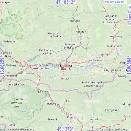
46° 37' 20.496" North, 14° 18' 20.556" East
| Map corner | latitude | longitude |
|---|---|---|
| Upper-left | 47.10312°, | 13.60259° |
| Center: | 46.62236°, | 14.30571° |
| Lower-right: | 46.1373°, | 15.00884° |
| Map W x H: | 107.4×107.4 km | = 66.7×66.7mi |
| max Lat: | 48.98333° ⇑97.6% North |
| 4.Bezirk: | 46.62236° |
| min Lat: | ⇓2.4% South 46.48841° |
| min Long | 4.Bezirk | max Long |
| 9.57802° | 14.30571° | 17.1° |
| W 42.3%⇐ | ⇒57.7% E |
Elevation
Elevation of 4.Bezirk is 450 m = 1476 ft, and this is 55.5 m = 182 ft below average elevation for this country.
| Max E: |
2140 m = 7021 ft | 50.1% |
| Avg. | 505.5 m = 1658 ft | |
| 4.Bezirk | 450 m = 1476 ft | |
Min E: |
118 m = 387 ft | 49.9% |
See also: Austria elevation on elevation.city.
Geographical zone
4.Bezirk is located in North temperate zone (between Tropic of Cancer and the Arctic Circle). Distance of this North polar circle is 2217.3 km =1377.8 mi to North.| Distance of | km | miles | from 4.Bezirk |
|---|---|---|---|
| North Pole | 4823.1 | 2996.9 | to North |
| Arctic Circle | 2217.3 | 1377.8 | to North |
| Tropic Cancer | 2578 | 1601.9 | to South |
| Equator | 5183.9 | 3221.1 | to South |


Nearby cities:
15 places around 4.Bezirk: (largest is in red/bold)
• 2.Bezirk
0.4 km =0.2 mi,  40°
40°
• 3.Bezirk
0.4 km =0.2 mi,  85°
85°
• Annabichl
3.2 km =2 mi,  15°
15°
• Ebenthal
4.7 km =2.9 mi,  109°
109°
• Innere Stadt
0.2 km =0.1 mi, 39°
• Klagenfurt am Wörthersee
0.3 km =0.2 mi,  352°
352°
• Reichersdorf
5.3 km =3.3 mi,  118°
118°
• Sankt Martin
1.8 km =1.1 mi,  249°
249°
• Sankt Peter
2.8 km =1.7 mi,  72°
72°
• Sankt Ruprecht
2.6 km =1.6 mi,  161°
161°
• St. Veiter Vorstadt
1 km =0.6 mi,  0°
0°
• Viktring
4.4 km =2.7 mi,  219°
219°
• Viktringer Vorstadt
0.6 km =0.4 mi,  151°
151°
• Villacher Vorstadt
1.3 km =0.8 mi,  276°
276°
• Völkermarkter Vorstadt
1.2 km =0.7 mi,  80°
80°
Sources, notices
• [Note1] Compared only with cities in Austria existing in our database
• [Src1] Map data: © OpenStreetMap contributors (CC-BY-SA)
• [Src2] Other city data from geonames.org with taken over terms of usage.
• [Src3] Geographical zone / Annual Mean Temperature by Robert A. Rohde @ Wikipedia
