Parap geodata
Parap (Northern Territory) is a section of populated place; located in Australia in Australia/Darwin (GMT+9.5) time zone. With population of 2,925 people, there are 2298 cities with bigger population in this country. Compared to other cities in Australia, 99.2% of cities are located further ↓South; 88.4% of cities are located further →East and 68.6% of cities have higher elevation than Parap. Note1


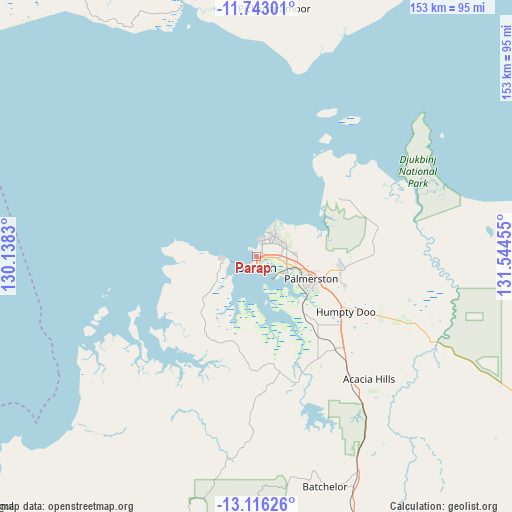
Parap GPS coordinates[2]
12° 25' 49.944" South, 130° 50' 29.112" East
| Map corner | latitude | longitude |
|---|---|---|
| Upper-left | -11.74301°, | 130.1383° |
| Center: | -12.43054°, | 130.84142° |
| Lower-right: | -13.11626°, | 131.54455° |
| Map W x H: | 152.7×152.7 km | = 94.9×94.9mi |
| max Lat: | -10.58257° ⇑0.8% North |
| Parap: | -12.43054° |
| min Lat: | ⇓99.2% South -43.31423° |
| min Long | Parap | max Long |
| 113.53327° | 130.84142° | 153.61246° |
| W 11.6%⇐ | ⇒88.4% E |
Elevation
Elevation of Parap is 24 m = 79 ft, and this is 98 m = 322 ft below average elevation for this country.
| Max E: |
1715 m = 5627 ft | 68.6% |
| Avg. | 122 m = 400 ft | |
| Parap | 24 m = 79 ft | |
Min E: |
-2 m = -7 ft | 31.4% |
See also: Australia elevation on elevation.city.
Geographical zone
Parap is located in South Torrid zone (between Equator and Tropic of Capricorn). Distance of this Southern Tropic circle is 1223.8 km =760.4 mi to South.| Distance of | km | miles | from Parap |
|---|---|---|---|
| Equator | 1382.1 | 858.8 | to North |
| Tropic Capricorn | 1223.8 | 760.4 | to South |
| Antarctic Circle | 6019 | 3740 | to South |
| South Pole | 8624.9 | 5359.3 | to South |


Nearby cities:
15 places around Parap: (largest is in red/bold)
• Coconut Grove
4 km =2.5 mi,  16°
16°
• Darwin
3.4 km =2.1 mi,  179°
179°
• Eaton
4.7 km =2.9 mi,  64°
64°
• Fannie Bay
1 km =0.6 mi,  327°
327°
• Jingili
5.7 km =3.5 mi,  36°
36°
• Larrakeyah
2.9 km =1.8 mi,  200°
200°
• Ludmilla
1.9 km =1.2 mi,  52°
52°
• Millner
4.9 km =3 mi,  28°
28°
• Nightcliff
5.4 km =3.4 mi,  11°
11°
• Rapid Creek
5.9 km =3.7 mi, 19°
• Stuart Park
2 km =1.2 mi, 176°
• The Gardens
2.1 km =1.3 mi,  193°
193°
• The Narrows
2 km =1.2 mi,  76°
76°
• Winnellie
4.8 km =3 mi,  88°
88°
• Woolner
1.1 km =0.7 mi,  139°
139°
Sources, notices
• [Note1] Compared only with cities in Australia existing in our database
• [Src1] Map data: © OpenStreetMap contributors (CC-BY-SA)
• [Src2] Other city data from geonames.org with taken over terms of usage.
• [Src3] Geographical zone / Annual Mean Temperature by Robert A. Rohde @ Wikipedia
