Windsor geodata
Windsor (Victoria) is a section of populated place; located in Australia in Australia/Melbourne (GMT+11) time zone. With population of 7,257 people, there are 942 cities with bigger population in this country. Compared to other cities in Australia, 89.3% of cities are located further ↑North; 66.6% of cities are located further →East and 67.2% of cities have higher elevation than Windsor. Note1


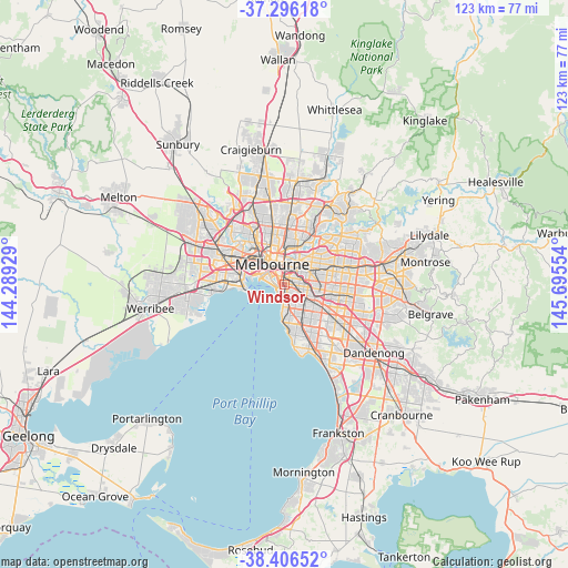
Windsor GPS coordinates[2]
37° 51' 12.384" South, 144° 59' 32.676" East
| Map corner | latitude | longitude |
|---|---|---|
| Upper-left | -37.29618°, | 144.28929° |
| Center: | -37.85344°, | 144.99241° |
| Lower-right: | -38.40652°, | 145.69554° |
| Map W x H: | 123.5×123.5 km | = 76.7×76.7mi |
| max Lat: | -10.58257° ⇑89.3% North |
| Windsor: | -37.85344° |
| min Lat: | ⇓10.7% South -43.31423° |
| min Long | Windsor | max Long |
| 113.53327° | 144.99241° | 153.61246° |
| W 33.4%⇐ | ⇒66.6% E |
Elevation
Elevation of Windsor is 25 m = 82 ft, and this is 97 m = 318 ft below average elevation for this country.
| Max E: |
1715 m = 5627 ft | 67.2% |
| Avg. | 122 m = 400 ft | |
| Windsor | 25 m = 82 ft | |
Min E: |
-2 m = -7 ft | 32.8% |
See also: Australia elevation on elevation.city.
Geographical zone
Windsor is located in South temperate zone (between Tropic of Capricorn and the Antarctic Circle). Distance of this Southern Tropic circle is 1603 km =996.1 mi to North.| Distance of | km | miles | from Windsor |
|---|---|---|---|
| Equator | 4208.9 | 2615.3 | to North |
| Tropic Capricorn | 1603 | 996.1 | to North |
| Antarctic Circle | 3192.3 | 1983.6 | to South |
| South Pole | 5798.2 | 3602.8 | to South |


Nearby cities:
15 places around Windsor: (largest is in red/bold)
• Armadale
2.5 km =1.6 mi,  95°
95°
• Balaclava
1.6 km =1 mi,  155°
155°
• Burnley
3.4 km =2.1 mi,  39°
39°
• Cremorne
2.4 km =1.5 mi,  2°
2°
• Elwood
3.3 km =2.1 mi,  195°
195°
• Malvern
3.3 km =2.1 mi,  107°
107°
• Middle Park
2.7 km =1.7 mi,  275°
275°
• Prahran
0.3 km =0.2 mi,  14°
14°
• Ripponlea
3.4 km =2.1 mi,  168°
168°
• Saint Kilda
1.9 km =1.2 mi,  212°
212°
• South Melbourne
3.2 km =2 mi,  314°
314°
• South Yarra
1.7 km =1.1 mi,  357°
357°
• St Kilda East
1.5 km =0.9 mi,  153°
153°
• St Kilda West
2 km =1.2 mi,  249°
249°
• Toorak
2.3 km =1.4 mi,  55°
55°
Sources, notices
• [Note1] Compared only with cities in Australia existing in our database
• [Src1] Map data: © OpenStreetMap contributors (CC-BY-SA)
• [Src2] Other city data from geonames.org with taken over terms of usage.
• [Src3] Geographical zone / Annual Mean Temperature by Robert A. Rohde @ Wikipedia
