Vineyard geodata
Vineyard (New South Wales) is a section of populated place; located in Australia in Australia/Sydney (GMT+11) time zone. With population of 1,196 people, there are 3589 cities with bigger population in this country. Compared to other cities in Australia, 52.1% of cities are located further ↓South; 63.9% of cities are located further ←West and 55.9% of cities have higher elevation than Vineyard. Note1


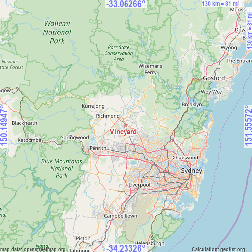
Vineyard GPS coordinates[2]
33° 38' 59.82" South, 150° 51' 9.324" East
| Map corner | latitude | longitude |
|---|---|---|
| Upper-left | -33.06266°, | 150.14947° |
| Center: | -33.64995°, | 150.85259° |
| Lower-right: | -34.23326°, | 151.55572° |
| Map W x H: | 130.2×130.2 km | = 80.9×80.9mi |
| max Lat: | -10.58257° ⇑47.9% North |
| Vineyard: | -33.64995° |
| min Lat: | ⇓52.1% South -43.31423° |
| min Long | Vineyard | max Long |
| 113.53327° | 150.85259° | 153.61246° |
| W 63.9%⇐ | ⇒36.1% E |
Elevation
Elevation of Vineyard is 37 m = 121 ft, and this is 85 m = 279 ft below average elevation for this country.
| Max E: |
1715 m = 5627 ft | 55.9% |
| Avg. | 122 m = 400 ft | |
| Vineyard | 37 m = 121 ft | |
Min E: |
-2 m = -7 ft | 44.1% |
See also: Australia elevation on elevation.city.
Geographical zone
Vineyard is located in South temperate zone (between Tropic of Capricorn and the Antarctic Circle). Distance of this Southern Tropic circle is 1135.6 km =705.6 mi to North.| Distance of | km | miles | from Vineyard |
|---|---|---|---|
| Equator | 3741.5 | 2324.9 | to North |
| Tropic Capricorn | 1135.6 | 705.6 | to North |
| Antarctic Circle | 3659.7 | 2274 | to South |
| South Pole | 6265.5 | 3893.2 | to South |


Nearby cities:
15 places around Vineyard: (largest is in red/bold)
• Berkshire Park
7.6 km =4.7 mi,  250°
250°
• Bligh Park
4.8 km =3 mi,  283°
283°
• Colebee
8.7 km =5.4 mi,  183°
183°
• Kellyville Ridge
8.3 km =5.2 mi,  133°
133°
• Marsden Park
4.9 km =3 mi,  196°
196°
• McGraths Hill
4.2 km =2.6 mi,  335°
335°
• Oakville
4.6 km =2.9 mi,  33°
33°
• Pitt Town
7 km =4.3 mi,  4°
4°
• Riverstone
3.9 km =2.4 mi,  160°
160°
• Rouse Hill
6.8 km =4.2 mi,  121°
121°
• Schofields
7.5 km =4.7 mi,  170°
170°
• South Windsor
5.7 km =3.5 mi,  308°
308°
• The Ponds
7.9 km =4.9 mi,  137°
137°
• Windsor
5.4 km =3.4 mi,  319°
319°
• Windsor Downs
4 km =2.5 mi,  256°
256°
Sources, notices
• [Note1] Compared only with cities in Australia existing in our database
• [Src1] Map data: © OpenStreetMap contributors (CC-BY-SA)
• [Src2] Other city data from geonames.org with taken over terms of usage.
• [Src3] Geographical zone / Annual Mean Temperature by Robert A. Rohde @ Wikipedia
