Taree geodata
Taree (New South Wales) is a populated place; located in Australia in Australia/Sydney (GMT+11) time zone. With population of 16,359 people, there are 233 cities with bigger population in this country. Compared to other cities in Australia, 66.5% of cities are located further ↓South; 84.3% of cities are located further ←West and 61.8% of cities have higher elevation than Taree. Note1


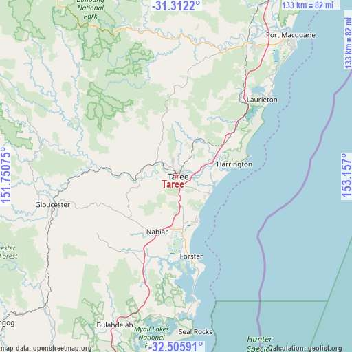
Taree GPS coordinates[2]
31° 54' 39.564" South, 152° 27' 13.932" East
| Map corner | latitude | longitude |
|---|---|---|
| Upper-left | -31.3122°, | 151.75075° |
| Center: | -31.91099°, | 152.45387° |
| Lower-right: | -32.50591°, | 153.157° |
| Map W x H: | 132.7×132.7 km | = 82.5×82.5mi |
| max Lat: | -10.58257° ⇑33.5% North |
| Taree: | -31.91099° |
| min Lat: | ⇓66.5% South -43.31423° |
| min Long | Taree | max Long |
| 113.53327° | 152.45387° | 153.61246° |
| W 84.3%⇐ | ⇒15.7% E |
Elevation
Elevation of Taree is 30 m = 98 ft, and this is 92 m = 302 ft below average elevation for this country.
| Max E: |
1715 m = 5627 ft | 61.8% |
| Avg. | 122 m = 400 ft | |
| Taree | 30 m = 98 ft | |
Min E: |
-2 m = -7 ft | 38.2% |
See also: Australia elevation on elevation.city.
Geographical zone
Taree is located in South temperate zone (between Tropic of Capricorn and the Antarctic Circle). Distance of this Southern Tropic circle is 942.3 km =585.5 mi to North.| Distance of | km | miles | from Taree |
|---|---|---|---|
| Equator | 3548.2 | 2204.7 | to North |
| Tropic Capricorn | 942.3 | 585.5 | to North |
| Antarctic Circle | 3853 | 2394.1 | to South |
| South Pole | 6458.9 | 4013.4 | to South |


Nearby cities:
15 places around Taree: (largest is in red/bold)
• Black Head
19.4 km =12.1 mi,  156°
156°
• Coopernook
17.7 km =11 mi,  57°
57°
• Cundletown
6.6 km =4.1 mi,  73°
73°
• Diamond Beach
16.6 km =10.3 mi,  152°
152°
• Failford
20.1 km =12.5 mi,  182°
182°
• Hallidays Point
17.9 km =11.1 mi,  165°
165°
• Harrington
19.6 km =12.2 mi,  80°
80°
• Lansdowne
16.2 km =10.1 mi,  28°
28°
• Old Bar
14.2 km =8.8 mi,  117°
117°
• Rainbow Flat
13.9 km =8.6 mi, 168°
• Red Head
18 km =11.2 mi, 154°
• Tallwoods Village
16.9 km =10.5 mi, 161°
• Tinonee
4.7 km =2.9 mi,  232°
232°
• Wallabi Point
14.3 km =8.9 mi,  130°
130°
• Wingham
9.3 km =5.8 mi,  301°
301°
Sources, notices
• [Note1] Compared only with cities in Australia existing in our database
• [Src1] Map data: © OpenStreetMap contributors (CC-BY-SA)
• [Src2] Other city data from geonames.org with taken over terms of usage.
• [Src3] Geographical zone / Annual Mean Temperature by Robert A. Rohde @ Wikipedia
