Lockwood geodata
Lockwood (Victoria) is a populated place; located in Australia in Australia/Melbourne (GMT+11) time zone. With population of 752 people, there are 4239 cities with bigger population in this country. Compared to other cities in Australia, 81.1% of cities are located further ↑North; 72.1% of cities are located further →East and 83.4% of cities have lower elevation than Lockwood. Note1


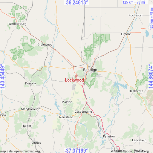
Lockwood GPS coordinates[2]
36° 48' 40.068" South, 144° 9' 27.396" East
| Map corner | latitude | longitude |
|---|---|---|
| Upper-left | -36.24613°, | 143.45449° |
| Center: | -36.81113°, | 144.15761° |
| Lower-right: | -37.37199°, | 144.86074° |
| Map W x H: | 125.2×125.2 km | = 77.8×77.8mi |
| max Lat: | -10.58257° ⇑81.1% North |
| Lockwood: | -36.81113° |
| min Lat: | ⇓18.9% South -43.31423° |
| min Long | Lockwood | max Long |
| 113.53327° | 144.15761° | 153.61246° |
| W 27.9%⇐ | ⇒72.1% E |
Elevation
Elevation of Lockwood is 222 m = 728 ft, and this is 100 m = 328 ft above average elevation for this country.
| Max E: |
1715 m = 5627 ft | 16.6% |
| Lockwood | 222 m 728 ft | |
| Avg. | 122 m = 400 ft | |
Min E: |
-2 m = -7 ft | 83.4% |
See also: Australia elevation on elevation.city.
Geographical zone
Lockwood is located in South temperate zone (between Tropic of Capricorn and the Antarctic Circle). Distance of this Southern Tropic circle is 1487.1 km =924 mi to North.| Distance of | km | miles | from Lockwood |
|---|---|---|---|
| Equator | 4093 | 2543.3 | to North |
| Tropic Capricorn | 1487.1 | 924 | to North |
| Antarctic Circle | 3308.2 | 2055.6 | to South |
| South Pole | 5914 | 3674.8 | to South |


Nearby cities:
15 places around Lockwood: (largest is in red/bold)
• Bendigo
12.4 km =7.7 mi,  61°
61°
• Bendigo city centre
12.4 km =7.7 mi, 60°
• California Gully
13 km =8.1 mi,  45°
45°
• Eaglehawk
13.4 km =8.3 mi,  38°
38°
• Flora Hill
12.7 km =7.9 mi,  74°
74°
• Golden Square
9.5 km =5.9 mi, 63°
• Ironbark
11.3 km =7 mi, 56°
• Kangaroo Flat
8.3 km =5.2 mi,  81°
81°
• Lockwood South
3.6 km =2.2 mi,  178°
178°
• Long Gully
11.7 km =7.3 mi, 49°
• Maiden Gully
7.8 km =4.8 mi, 35°
• Mandurang
12.7 km =7.9 mi,  92°
92°
• Marong
8.9 km =5.5 mi,  345°
345°
• Quarry Hill
11.6 km =7.2 mi, 70°
• Sailors Gully
13.3 km =8.3 mi,  32°
32°
Sources, notices
• [Note1] Compared only with cities in Australia existing in our database
• [Src1] Map data: © OpenStreetMap contributors (CC-BY-SA)
• [Src2] Other city data from geonames.org with taken over terms of usage.
• [Src3] Geographical zone / Annual Mean Temperature by Robert A. Rohde @ Wikipedia
