Leumeah geodata
Leumeah (New South Wales) is a section of populated place; located in Australia in Australia/Sydney (GMT+11) time zone. With population of 9,767 people, there are 621 cities with bigger population in this country. Compared to other cities in Australia, 60% of cities are located further ↑North; 63.3% of cities are located further ←West and 58% of cities have lower elevation than Leumeah. Note1


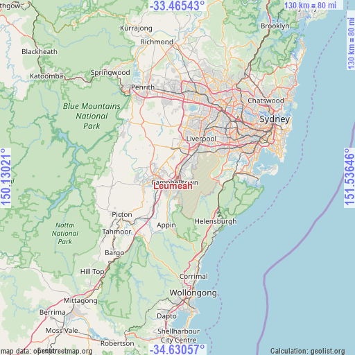
Leumeah GPS coordinates[2]
34° 3' 0" South, 150° 49' 59.988" East
| Map corner | latitude | longitude |
|---|---|---|
| Upper-left | -33.46543°, | 150.13021° |
| Center: | -34.05°, | 150.83333° |
| Lower-right: | -34.63057°, | 151.53646° |
| Map W x H: | 129.6×129.6 km | = 80.5×80.5mi |
| max Lat: | -10.58257° ⇑60% North |
| Leumeah: | -34.05° |
| min Lat: | ⇓40% South -43.31423° |
| min Long | Leumeah | max Long |
| 113.53327° | 150.83333° | 153.61246° |
| W 63.3%⇐ | ⇒36.7% E |
Elevation
Elevation of Leumeah is 59 m = 194 ft, and this is 63 m = 207 ft below average elevation for this country.
| Max E: |
1715 m = 5627 ft | 42% |
| Avg. | 122 m = 400 ft | |
| Leumeah | 59 m = 194 ft | |
Min E: |
-2 m = -7 ft | 58% |
See also: Australia elevation on elevation.city.
Geographical zone
Leumeah is located in South temperate zone (between Tropic of Capricorn and the Antarctic Circle). Distance of this Southern Tropic circle is 1180.1 km =733.3 mi to North.| Distance of | km | miles | from Leumeah |
|---|---|---|---|
| Equator | 3786 | 2352.5 | to North |
| Tropic Capricorn | 1180.1 | 733.3 | to North |
| Antarctic Circle | 3615.2 | 2246.4 | to South |
| South Pole | 6221.1 | 3865.6 | to South |


Nearby cities:
15 places around Leumeah: (largest is in red/bold)
• Airds
4 km =2.5 mi,  180°
180°
• Blair Athol
3.2 km =2 mi,  245°
245°
• Bow Bowing
3.8 km =2.4 mi,  9°
9°
• Bradbury
4.3 km =2.7 mi,  202°
202°
• Campbelltown
2.4 km =1.5 mi,  219°
219°
• Claymore
2.1 km =1.3 mi,  280°
280°
• Eagle Vale
2.3 km =1.4 mi,  307°
307°
• Eschol Park
3.1 km =1.9 mi,  315°
315°
• Kearns
4.3 km =2.7 mi, 316°
• Kentlyn
3.2 km =2 mi,  111°
111°
• Minto
2.4 km =1.5 mi,  39°
39°
• Raby
3.8 km =2.4 mi,  337°
337°
• Ruse
2.3 km =1.4 mi,  160°
160°
• St Andrews
3.1 km =1.9 mi,  353°
353°
• Woodbine
1.2 km =0.7 mi,  292°
292°
Sources, notices
• [Note1] Compared only with cities in Australia existing in our database
• [Src1] Map data: © OpenStreetMap contributors (CC-BY-SA)
• [Src2] Other city data from geonames.org with taken over terms of usage.
• [Src3] Geographical zone / Annual Mean Temperature by Robert A. Rohde @ Wikipedia
