Kincumber geodata
Kincumber (New South Wales) is a populated place; located in Australia in Australia/Sydney (GMT+11) time zone. With population of 707 people, there are 4316 cities with bigger population in this country. Compared to other cities in Australia, 53.7% of cities are located further ↓South; 76.9% of cities are located further ←West and 64.9% of cities have lower elevation than Kincumber. Note1


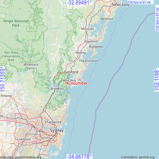
Kincumber GPS coordinates[2]
33° 28' 59.988" South, 151° 25' 0.012" East
| Map corner | latitude | longitude |
|---|---|---|
| Upper-left | -32.89491°, | 150.71355° |
| Center: | -33.48333°, | 151.41667° |
| Lower-right: | -34.06778°, | 152.1198° |
| Map W x H: | 130.4×130.4 km | = 81×81mi |
| max Lat: | -10.58257° ⇑46.3% North |
| Kincumber: | -33.48333° |
| min Lat: | ⇓53.7% South -43.31423° |
| min Long | Kincumber | max Long |
| 113.53327° | 151.41667° | 153.61246° |
| W 76.9%⇐ | ⇒23.1% E |
Elevation
Elevation of Kincumber is 80 m = 262 ft, and this is 42 m = 138 ft below average elevation for this country.
| Max E: |
1715 m = 5627 ft | 35.1% |
| Avg. | 122 m = 400 ft | |
| Kincumber | 80 m = 262 ft | |
Min E: |
-2 m = -7 ft | 64.9% |
See also: Australia elevation on elevation.city.
Geographical zone
Kincumber is located in South temperate zone (between Tropic of Capricorn and the Antarctic Circle). Distance of this Southern Tropic circle is 1117.1 km =694.1 mi to North.| Distance of | km | miles | from Kincumber |
|---|---|---|---|
| Equator | 3723 | 2313.4 | to North |
| Tropic Capricorn | 1117.1 | 694.1 | to North |
| Antarctic Circle | 3678.2 | 2285.5 | to South |
| South Pole | 6284.1 | 3904.8 | to South |


Nearby cities:
15 places around Kincumber: (largest is in red/bold)
• Avoca Beach
2.3 km =1.4 mi,  43°
43°
• Bensville
3.7 km =2.3 mi,  244°
244°
• Booker Bay
7.3 km =4.5 mi, 243°
• Copacabana
1.8 km =1.1 mi,  102°
102°
• Daleys Point
5.9 km =3.7 mi,  255°
255°
• Davistown
5.1 km =3.2 mi,  267°
267°
• Empire Bay
5.1 km =3.2 mi, 256°
• Erina
6.2 km =3.9 mi,  336°
336°
• Killcare Heights
6.4 km =4 mi,  224°
224°
• Kincumber South
3.7 km =2.3 mi, 264°
• Macmasters Beach
1.6 km =1 mi,  161°
161°
• North Avoca
3.5 km =2.2 mi,  29°
29°
• Saratoga
6.1 km =3.8 mi,  278°
278°
• St Huberts Island
6.7 km =4.2 mi, 258°
• Terrigal
4.8 km =3 mi, 35°
Sources, notices
• [Note1] Compared only with cities in Australia existing in our database
• [Src1] Map data: © OpenStreetMap contributors (CC-BY-SA)
• [Src2] Other city data from geonames.org with taken over terms of usage.
• [Src3] Geographical zone / Annual Mean Temperature by Robert A. Rohde @ Wikipedia
