Kennington geodata
Kennington (Victoria) is a section of populated place; located in Australia in Australia/Melbourne (GMT+11) time zone. With population of 5,545 people, there are 1334 cities with bigger population in this country. Compared to other cities in Australia, 80.9% of cities are located further ↑North; 71.4% of cities are located further →East and 86.2% of cities have lower elevation than Kennington. Note1


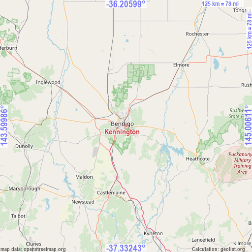
Kennington GPS coordinates[2]
36° 46' 16.608" South, 144° 18' 10.728" East
| Map corner | latitude | longitude |
|---|---|---|
| Upper-left | -36.20599°, | 143.59986° |
| Center: | -36.77128°, | 144.30298° |
| Lower-right: | -37.33243°, | 145.00611° |
| Map W x H: | 125.2×125.2 km | = 77.8×77.8mi |
| max Lat: | -10.58257° ⇑80.9% North |
| Kennington: | -36.77128° |
| min Lat: | ⇓19.1% South -43.31423° |
| min Long | Kennington | max Long |
| 113.53327° | 144.30298° | 153.61246° |
| W 28.6%⇐ | ⇒71.4% E |
Elevation
Elevation of Kennington is 270 m = 886 ft, and this is 148 m = 486 ft above average elevation for this country.
| Max E: |
1715 m = 5627 ft | 13.8% |
| Kennington | 270 m 886 ft | |
| Avg. | 122 m = 400 ft | |
Min E: |
-2 m = -7 ft | 86.2% |
See also: Australia elevation on elevation.city.
Geographical zone
Kennington is located in South temperate zone (between Tropic of Capricorn and the Antarctic Circle). Distance of this Southern Tropic circle is 1482.7 km =921.3 mi to North.| Distance of | km | miles | from Kennington |
|---|---|---|---|
| Equator | 4088.6 | 2540.5 | to North |
| Tropic Capricorn | 1482.7 | 921.3 | to North |
| Antarctic Circle | 3312.6 | 2058.4 | to South |
| South Pole | 5918.5 | 3677.6 | to South |


Nearby cities:
15 places around Kennington: (largest is in red/bold)
• Bendigo
2.5 km =1.6 mi,  305°
305°
• Bendigo city centre
2.6 km =1.6 mi, 307°
• California Gully
6 km =3.7 mi,  321°
321°
• East Bendigo
3.6 km =2.2 mi,  23°
23°
• Flora Hill
1.3 km =0.8 mi,  210°
210°
• Golden Square
4.5 km =2.8 mi,  268°
268°
• Ironbark
3.9 km =2.4 mi,  297°
297°
• Junortoun
5.4 km =3.4 mi,  89°
89°
• Kangaroo Flat
5.7 km =3.5 mi,  235°
235°
• Long Gully
5.1 km =3.2 mi, 307°
• Mandurang
5.1 km =3.2 mi,  183°
183°
• North Bendigo
3.4 km =2.1 mi,  336°
336°
• Quarry Hill
2.1 km =1.3 mi,  254°
254°
• Strathdale
1.3 km =0.8 mi,  60°
60°
• White Hills
4.7 km =2.9 mi,  2°
2°
Sources, notices
• [Note1] Compared only with cities in Australia existing in our database
• [Src1] Map data: © OpenStreetMap contributors (CC-BY-SA)
• [Src2] Other city data from geonames.org with taken over terms of usage.
• [Src3] Geographical zone / Annual Mean Temperature by Robert A. Rohde @ Wikipedia
