Gordon geodata
Gordon (New South Wales) is a section of populated place; located in Australia in Australia/Sydney (GMT+11) time zone. With population of 7,567 people, there are 894 cities with bigger population in this country. Compared to other cities in Australia, 50.5% of cities are located further ↑North; 71.8% of cities are located further ←West and 73.7% of cities have lower elevation than Gordon. Note1


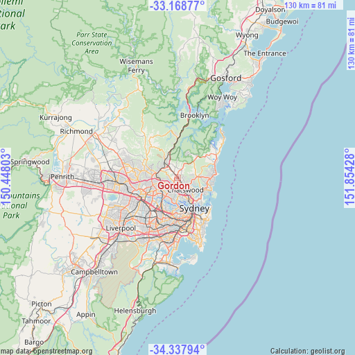
Gordon GPS coordinates[2]
33° 45' 19.26" South, 151° 9' 4.14" East
| Map corner | latitude | longitude |
|---|---|---|
| Upper-left | -33.16877°, | 150.44803° |
| Center: | -33.75535°, | 151.15115° |
| Lower-right: | -34.33794°, | 151.85428° |
| Map W x H: | 130×130 km | = 80.8×80.8mi |
| max Lat: | -10.58257° ⇑50.5% North |
| Gordon: | -33.75535° |
| min Lat: | ⇓49.5% South -43.31423° |
| min Long | Gordon | max Long |
| 113.53327° | 151.15115° | 153.61246° |
| W 71.8%⇐ | ⇒28.2% E |
Elevation
Elevation of Gordon is 121 m = 397 ft, and this is 1 m = 3 ft below average elevation for this country.
| Max E: |
1715 m = 5627 ft | 26.3% |
| Avg. | 122 m = 400 ft | |
| Gordon | 121 m = 397 ft | |
Min E: |
-2 m = -7 ft | 73.7% |
See also: Australia elevation on elevation.city.
Geographical zone
Gordon is located in South temperate zone (between Tropic of Capricorn and the Antarctic Circle). Distance of this Southern Tropic circle is 1147.3 km =712.9 mi to North.| Distance of | km | miles | from Gordon |
|---|---|---|---|
| Equator | 3753.2 | 2332.1 | to North |
| Tropic Capricorn | 1147.3 | 712.9 | to North |
| Antarctic Circle | 3647.9 | 2266.7 | to South |
| South Pole | 6253.8 | 3885.9 | to South |


Nearby cities:
15 places around Gordon: (largest is in red/bold)
• Chatswood West
4.5 km =2.8 mi,  163°
163°
• Davidson
4.8 km =3 mi,  73°
73°
• East Killara
2.8 km =1.7 mi,  90°
90°
• East Lindfield
3.5 km =2.2 mi,  110°
110°
• Killara
1.6 km =1 mi,  139°
139°
• Lindfield
3.4 km =2.1 mi, 155°
• Macquarie Park
3.6 km =2.2 mi,  217°
217°
• North Turramurra
4.7 km =2.9 mi,  354°
354°
• Pymble
1.5 km =0.9 mi,  326°
326°
• Roseville
4.3 km =2.7 mi, 136°
• Saint Ives
3 km =1.9 mi,  15°
15°
• South Turramurra
3.6 km =2.2 mi,  280°
280°
• Turramurra
3.2 km =2 mi,  319°
319°
• Warrawee
4.1 km =2.5 mi, 316°
• West Pymble
2.1 km =1.3 mi,  232°
232°
Sources, notices
• [Note1] Compared only with cities in Australia existing in our database
• [Src1] Map data: © OpenStreetMap contributors (CC-BY-SA)
• [Src2] Other city data from geonames.org with taken over terms of usage.
• [Src3] Geographical zone / Annual Mean Temperature by Robert A. Rohde @ Wikipedia
