Cluden geodata
Cluden (Queensland) is a section of populated place; located in Australia in Australia/Brisbane (GMT+10) time zone. With population of 537 people, there are 4757 cities with bigger population in this country. Compared to other cities in Australia, 95% of cities are located further ↓South; 54% of cities are located further →East and 98.1% of cities have higher elevation than Cluden. Note1


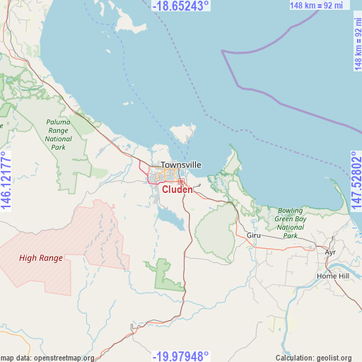
Cluden GPS coordinates[2]
19° 19' 2.28" South, 146° 49' 29.604" East
| Map corner | latitude | longitude |
|---|---|---|
| Upper-left | -18.65243°, | 146.12177° |
| Center: | -19.3173°, | 146.82489° |
| Lower-right: | -19.97948°, | 147.52802° |
| Map W x H: | 147.6×147.6 km | = 91.7×91.7mi |
| max Lat: | -10.58257° ⇑5% North |
| Cluden: | -19.3173° |
| min Lat: | ⇓95% South -43.31423° |
| min Long | Cluden | max Long |
| 113.53327° | 146.82489° | 153.61246° |
| W 46%⇐ | ⇒54% E |
Elevation
Elevation of Cluden is 4 m = 13 ft, and this is 118 m = 387 ft below average elevation for this country.
| Max E: |
1715 m = 5627 ft | 98.1% |
| Avg. | 122 m = 400 ft | |
| Cluden | 4 m = 13 ft | |
Min E: |
-2 m = -7 ft | 1.9% |
See also: Australia elevation on elevation.city.
Geographical zone
Cluden is located in South Torrid zone (between Equator and Tropic of Capricorn). Distance of this Southern Tropic circle is 458 km =284.6 mi to South.| Distance of | km | miles | from Cluden |
|---|---|---|---|
| Equator | 2147.9 | 1334.6 | to North |
| Tropic Capricorn | 458 | 284.6 | to South |
| Antarctic Circle | 5253.3 | 3264.2 | to South |
| South Pole | 7859.2 | 4883.5 | to South |


Nearby cities:
15 places around Cluden: (largest is in red/bold)
• Aitkenvale
5.9 km =3.7 mi,  287°
287°
• Annandale
3.6 km =2.2 mi,  274°
274°
• Hermit Park
4.2 km =2.6 mi,  322°
322°
• Hyde Park
5.4 km =3.4 mi,  326°
326°
• Idalia
1.6 km =1 mi, 315°
• Mundingburra
3.9 km =2.4 mi,  302°
302°
• Murray
3.1 km =1.9 mi, 268°
• Mysterton
4.7 km =2.9 mi, 319°
• Oonoonba
2.3 km =1.4 mi,  349°
349°
• Pimlico
5.5 km =3.4 mi, 315°
• Railway Estate
4.7 km =2.9 mi, 353°
• Rosslea
3.5 km =2.2 mi,  306°
306°
• South Townsville
5.8 km =3.6 mi,  8°
8°
• Stuart
3.9 km =2.4 mi,  149°
149°
• Wulguru
1.4 km =0.9 mi,  208°
208°
Sources, notices
• [Note1] Compared only with cities in Australia existing in our database
• [Src1] Map data: © OpenStreetMap contributors (CC-BY-SA)
• [Src2] Other city data from geonames.org with taken over terms of usage.
• [Src3] Geographical zone / Annual Mean Temperature by Robert A. Rohde @ Wikipedia
