Boambee geodata
Boambee (New South Wales) is a populated place; located in Australia in Australia/Sydney (GMT+11) time zone. With population of 1,629 people, there are 3161 cities with bigger population in this country. Compared to other cities in Australia, 71.8% of cities are located further ↓South; 93.9% of cities are located further ←West and 59.2% of cities have higher elevation than Boambee. Note1


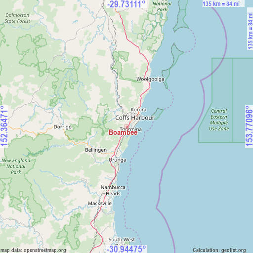
Boambee GPS coordinates[2]
30° 20' 23.316" South, 153° 4' 4.188" East
| Map corner | latitude | longitude |
|---|---|---|
| Upper-left | -29.73111°, | 152.36471° |
| Center: | -30.33981°, | 153.06783° |
| Lower-right: | -30.94475°, | 153.77096° |
| Map W x H: | 134.9×134.9 km | = 83.8×83.8mi |
| max Lat: | -10.58257° ⇑28.2% North |
| Boambee: | -30.33981° |
| min Lat: | ⇓71.8% South -43.31423° |
| min Long | Boambee | max Long |
| 113.53327° | 153.06783° | 153.61246° |
| W 93.9%⇐ | ⇒6.1% E |
Elevation
Elevation of Boambee is 33 m = 108 ft, and this is 89 m = 292 ft below average elevation for this country.
| Max E: |
1715 m = 5627 ft | 59.2% |
| Avg. | 122 m = 400 ft | |
| Boambee | 33 m = 108 ft | |
Min E: |
-2 m = -7 ft | 40.8% |
See also: Australia elevation on elevation.city.
Geographical zone
Boambee is located in South temperate zone (between Tropic of Capricorn and the Antarctic Circle). Distance of this Southern Tropic circle is 767.6 km =477 mi to North.| Distance of | km | miles | from Boambee |
|---|---|---|---|
| Equator | 3373.5 | 2096.2 | to North |
| Tropic Capricorn | 767.6 | 477 | to North |
| Antarctic Circle | 4027.7 | 2502.7 | to South |
| South Pole | 6633.6 | 4121.9 | to South |


Nearby cities:
15 places around Boambee: (largest is in red/bold)
• Boambee East
0.9 km =0.6 mi,  145°
145°
• Bonville
4.8 km =3 mi,  189°
189°
• Coffs Harbour
6.5 km =4 mi,  42°
42°
• Coramba
14.3 km =8.9 mi,  338°
338°
• Karangi
8.3 km =5.2 mi,  348°
348°
• Korora
11.3 km =7 mi,  23°
23°
• Moonee Beach
17 km =10.6 mi,  28°
28°
• North Boambee Valley
3 km =1.9 mi,  2°
2°
• Raleigh
14.5 km =9 mi,  219°
219°
• Repton
11.8 km =7.3 mi, 194°
• Sapphire Beach
14.2 km =8.8 mi, 27°
• Sawtell
4.2 km =2.6 mi,  130°
130°
• Toormina
2.5 km =1.6 mi, 128°
• Upper Orara
9 km =5.6 mi,  313°
313°
• Urunga
18.2 km =11.3 mi,  196°
196°
Sources, notices
• [Note1] Compared only with cities in Australia existing in our database
• [Src1] Map data: © OpenStreetMap contributors (CC-BY-SA)
• [Src2] Other city data from geonames.org with taken over terms of usage.
• [Src3] Geographical zone / Annual Mean Temperature by Robert A. Rohde @ Wikipedia
