Woolloongabba geodata
Woolloongabba (Queensland) is a section of populated place; located in Australia in Australia/Brisbane (GMT+10) time zone. With population of 6,321 people, there are 1123 cities with bigger population in this country. Compared to other cities in Australia, 82.2% of cities are located further ↓South; 92.6% of cities are located further ←West and 85% of cities have higher elevation than Woolloongabba. Note1


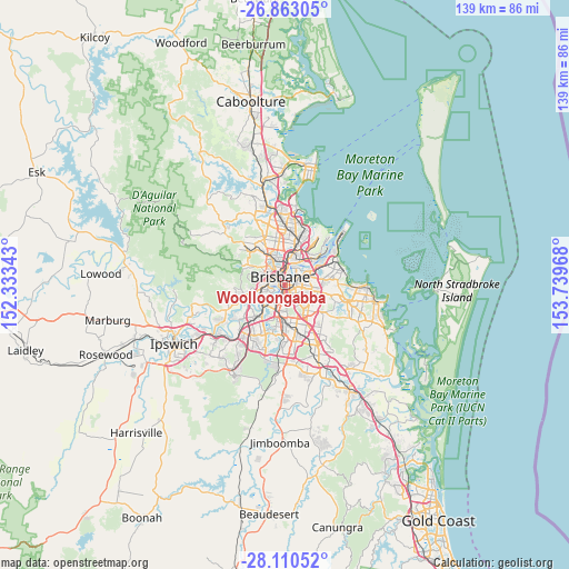
Woolloongabba GPS coordinates[2]
27° 29' 18.78" South, 153° 2' 11.58" East
| Map corner | latitude | longitude |
|---|---|---|
| Upper-left | -26.86305°, | 152.33343° |
| Center: | -27.48855°, | 153.03655° |
| Lower-right: | -28.11052°, | 153.73968° |
| Map W x H: | 138.7×138.7 km | = 86.2×86.2mi |
| max Lat: | -10.58257° ⇑17.8% North |
| Woolloongabba: | -27.48855° |
| min Lat: | ⇓82.2% South -43.31423° |
| min Long | Woolloongabba | max Long |
| 113.53327° | 153.03655° | 153.61246° |
| W 92.6%⇐ | ⇒7.4% E |
Elevation
Elevation of Woolloongabba is 12 m = 39 ft, and this is 110 m = 361 ft below average elevation for this country.
| Max E: |
1715 m = 5627 ft | 85% |
| Avg. | 122 m = 400 ft | |
| Woolloongabba | 12 m = 39 ft | |
Min E: |
-2 m = -7 ft | 15% |
See also: Australia elevation on elevation.city.
Geographical zone
Woolloongabba is located in South temperate zone (between Tropic of Capricorn and the Antarctic Circle). Distance of this Southern Tropic circle is 450.5 km =279.9 mi to North.| Distance of | km | miles | from Woolloongabba |
|---|---|---|---|
| Equator | 3056.4 | 1899.2 | to North |
| Tropic Capricorn | 450.5 | 279.9 | to North |
| Antarctic Circle | 4344.7 | 2699.7 | to South |
| South Pole | 6950.6 | 4318.9 | to South |


Nearby cities:
15 places around Woolloongabba: (largest is in red/bold)
• Annerley
2.7 km =1.7 mi,  188°
188°
• Brisbane
2.4 km =1.5 mi,  339°
339°
• Coorparoo
2.2 km =1.4 mi,  103°
103°
• Dutton Park
1.2 km =0.7 mi,  223°
223°
• East Brisbane
1.1 km =0.7 mi,  41°
41°
• Fairfield
2.3 km =1.4 mi,  210°
210°
• Greenslopes
2.5 km =1.6 mi,  149°
149°
• Hawthorne
3.2 km =2 mi, 41°
• Highgate Hill
1.8 km =1.1 mi,  267°
267°
• Kangaroo Point
1.3 km =0.8 mi,  0°
0°
• New Farm
2.6 km =1.6 mi,  26°
26°
• Norman Park
2.8 km =1.7 mi,  67°
67°
• South Brisbane
1.8 km =1.1 mi,  299°
299°
• Spring Hill
3.3 km =2.1 mi, 336°
• West End
2.9 km =1.8 mi,  291°
291°
Sources, notices
• [Note1] Compared only with cities in Australia existing in our database
• [Src1] Map data: © OpenStreetMap contributors (CC-BY-SA)
• [Src2] Other city data from geonames.org with taken over terms of usage.
• [Src3] Geographical zone / Annual Mean Temperature by Robert A. Rohde @ Wikipedia
