Sunshine Acres geodata
Sunshine Acres (Queensland) is a section of populated place; located in Australia in Australia/Brisbane (GMT+10) time zone. With population of 918 people, there are 3949 cities with bigger population in this country. Compared to other cities in Australia, 89.1% of cities are located further ↓South; 86.8% of cities are located further ←West and 74.7% of cities have higher elevation than Sunshine Acres. Note1


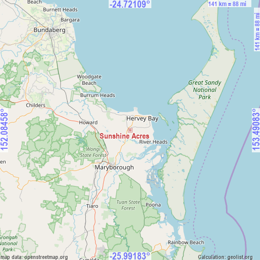
Sunshine Acres GPS coordinates[2]
25° 21' 29.268" South, 152° 47' 15.72" East
| Map corner | latitude | longitude |
|---|---|---|
| Upper-left | -24.72109°, | 152.08458° |
| Center: | -25.35813°, | 152.7877° |
| Lower-right: | -25.99183°, | 153.49083° |
| Map W x H: | 141.3×141.3 km | = 87.8×87.8mi |
| max Lat: | -10.58257° ⇑10.9% North |
| Sunshine Acres: | -25.35813° |
| min Lat: | ⇓89.1% South -43.31423° |
| min Long | Sunshine Acres | max Long |
| 113.53327° | 152.7877° | 153.61246° |
| W 86.8%⇐ | ⇒13.2% E |
Elevation
Elevation of Sunshine Acres is 19 m = 62 ft, and this is 103 m = 338 ft below average elevation for this country.
| Max E: |
1715 m = 5627 ft | 74.7% |
| Avg. | 122 m = 400 ft | |
| Sunshine Acres | 19 m = 62 ft | |
Min E: |
-2 m = -7 ft | 25.3% |
See also: Australia elevation on elevation.city.
Geographical zone
Sunshine Acres is located in South temperate zone (between Tropic of Capricorn and the Antarctic Circle). Distance of this Southern Tropic circle is 213.6 km =132.7 mi to North.| Distance of | km | miles | from Sunshine Acres |
|---|---|---|---|
| Equator | 2819.6 | 1752 | to North |
| Tropic Capricorn | 213.6 | 132.7 | to North |
| Antarctic Circle | 4581.6 | 2846.9 | to South |
| South Pole | 7187.5 | 4466.1 | to South |


Nearby cities:
15 places around Sunshine Acres: (largest is in red/bold)
• Booral
12.1 km =7.5 mi,  91°
91°
• Craignish
10.5 km =6.5 mi,  322°
322°
• Dundowran
7.2 km =4.5 mi,  348°
348°
• Dundowran Beach
10.2 km =6.3 mi, 345°
• Eli Waters
9 km =5.6 mi,  13°
13°
• Hervey Bay
8.1 km =5 mi, 346°
• Kawungan
8.8 km =5.5 mi,  41°
41°
• Nikenbah
4.6 km =2.9 mi,  20°
20°
• Pialba
9.7 km =6 mi, 35°
• Point Vernon
11.6 km =7.2 mi, 14°
• Scarness
10.7 km =6.6 mi, 39°
• Takura
10.3 km =6.4 mi,  295°
295°
• Torquay
12.3 km =7.6 mi,  48°
48°
• Urraween
7.8 km =4.8 mi,  26°
26°
• Wondunna
8.5 km =5.3 mi,  57°
57°
Sources, notices
• [Note1] Compared only with cities in Australia existing in our database
• [Src1] Map data: © OpenStreetMap contributors (CC-BY-SA)
• [Src2] Other city data from geonames.org with taken over terms of usage.
• [Src3] Geographical zone / Annual Mean Temperature by Robert A. Rohde @ Wikipedia
