Horsfield Bay geodata
Horsfield Bay (New South Wales) is a section of populated place; located in Australia in Australia/Sydney (GMT+11) time zone. With population of 530 people, there are 4780 cities with bigger population in this country. Compared to other cities in Australia, 53.5% of cities are located further ↓South; 75.8% of cities are located further ←West and 52% of cities have lower elevation than Horsfield Bay. Note1


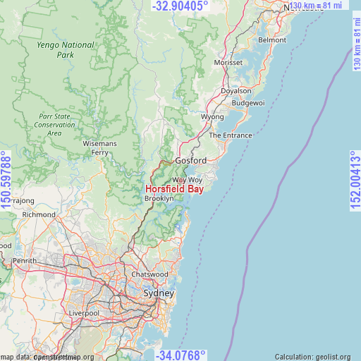
Horsfield Bay GPS coordinates[2]
33° 29' 32.676" South, 151° 18' 3.6" East
| Map corner | latitude | longitude |
|---|---|---|
| Upper-left | -32.90405°, | 150.59788° |
| Center: | -33.49241°, | 151.301° |
| Lower-right: | -34.0768°, | 152.00413° |
| Map W x H: | 130.4×130.4 km | = 81×81mi |
| max Lat: | -10.58257° ⇑46.5% North |
| Horsfield Bay: | -33.49241° |
| min Lat: | ⇓53.5% South -43.31423° |
| min Long | Horsfield Bay | max Long |
| 113.53327° | 151.301° | 153.61246° |
| W 75.8%⇐ | ⇒24.2% E |
Elevation
Elevation of Horsfield Bay is 48 m = 157 ft, and this is 74 m = 243 ft below average elevation for this country.
| Max E: |
1715 m = 5627 ft | 48% |
| Avg. | 122 m = 400 ft | |
| Horsfield Bay | 48 m = 157 ft | |
Min E: |
-2 m = -7 ft | 52% |
See also: Australia elevation on elevation.city.
Geographical zone
Horsfield Bay is located in South temperate zone (between Tropic of Capricorn and the Antarctic Circle). Distance of this Southern Tropic circle is 1118.1 km =694.8 mi to North.| Distance of | km | miles | from Horsfield Bay |
|---|---|---|---|
| Equator | 3724 | 2314 | to North |
| Tropic Capricorn | 1118.1 | 694.8 | to North |
| Antarctic Circle | 3677.2 | 2284.9 | to South |
| South Pole | 6283.1 | 3904.1 | to South |


Nearby cities:
15 places around Horsfield Bay: (largest is in red/bold)
• Blackwall
2.7 km =1.7 mi,  114°
114°
• Booker Bay
4.7 km =2.9 mi,  118°
118°
• Daleys Point
5 km =3.1 mi,  95°
95°
• Davistown
5.7 km =3.5 mi,  82°
82°
• Empire Bay
5.7 km =3.5 mi,  91°
91°
• Ettalong
4.1 km =2.5 mi, 123°
• Ettalong Beach
3.4 km =2.1 mi,  126°
126°
• Koolewong
3.3 km =2.1 mi,  24°
24°
• Pearl Beach
5.8 km =3.6 mi,  177°
177°
• Point Clare
5.9 km =3.7 mi, 24°
• Saratoga
5.1 km =3.2 mi,  68°
68°
• St Huberts Island
4.2 km =2.6 mi, 94°
• Tascott
4.8 km =3 mi,  14°
14°
• Umina Beach
3.6 km =2.2 mi,  161°
161°
• Woy Woy
2.4 km =1.5 mi, 67°
Sources, notices
• [Note1] Compared only with cities in Australia existing in our database
• [Src1] Map data: © OpenStreetMap contributors (CC-BY-SA)
• [Src2] Other city data from geonames.org with taken over terms of usage.
• [Src3] Geographical zone / Annual Mean Temperature by Robert A. Rohde @ Wikipedia
