Tolland geodata
Tolland (New South Wales) is a section of populated place; located in Australia in Australia/Sydney (GMT+11) time zone. With population of 3,329 people, there are 2057 cities with bigger population in this country. Compared to other cities in Australia, 73.5% of cities are located further ↑North; 50.7% of cities are located further →East and 83.3% of cities have lower elevation than Tolland. Note1


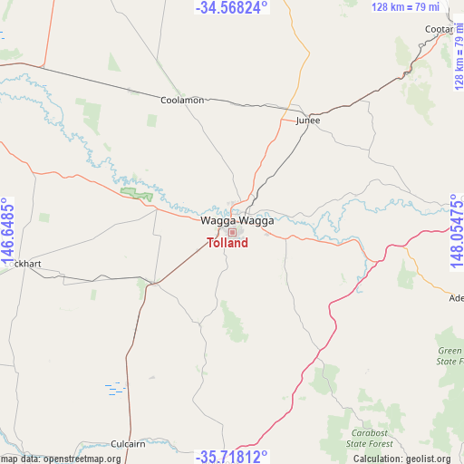
Tolland GPS coordinates[2]
35° 8' 42.756" South, 147° 21' 5.832" East
| Map corner | latitude | longitude |
|---|---|---|
| Upper-left | -34.56824°, | 146.6485° |
| Center: | -35.14521°, | 147.35162° |
| Lower-right: | -35.71812°, | 148.05475° |
| Map W x H: | 127.9×127.9 km | = 79.5×79.5mi |
| max Lat: | -10.58257° ⇑73.5% North |
| Tolland: | -35.14521° |
| min Lat: | ⇓26.5% South -43.31423° |
| min Long | Tolland | max Long |
| 113.53327° | 147.35162° | 153.61246° |
| W 49.3%⇐ | ⇒50.7% E |
Elevation
Elevation of Tolland is 221 m = 725 ft, and this is 99 m = 325 ft above average elevation for this country.
| Max E: |
1715 m = 5627 ft | 16.7% |
| Tolland | 221 m 725 ft | |
| Avg. | 122 m = 400 ft | |
Min E: |
-2 m = -7 ft | 83.3% |
See also: Australia elevation on elevation.city.
Geographical zone
Tolland is located in South temperate zone (between Tropic of Capricorn and the Antarctic Circle). Distance of this Southern Tropic circle is 1301.9 km =809 mi to North.| Distance of | km | miles | from Tolland |
|---|---|---|---|
| Equator | 3907.8 | 2428.2 | to North |
| Tropic Capricorn | 1301.9 | 809 | to North |
| Antarctic Circle | 3493.4 | 2170.7 | to South |
| South Pole | 6099.3 | 3789.9 | to South |


Nearby cities:
15 places around Tolland: (largest is in red/bold)
• Ashmont
2.9 km =1.8 mi,  321°
321°
• Boorooma
8 km =5 mi,  8°
8°
• Bourkelands
1.3 km =0.8 mi,  199°
199°
• Charles Sturt University
9.4 km =5.8 mi,  1°
1°
• Estella
8.1 km =5 mi, 3°
• Glenfield Park
1.9 km =1.2 mi,  297°
297°
• Kapooka
6.2 km =3.9 mi,  257°
257°
• Kooringal
2.3 km =1.4 mi,  77°
77°
• Lake Albert
3.7 km =2.3 mi,  129°
129°
• Lloyd
1.5 km =0.9 mi,  245°
245°
• Mount Austin
0.9 km =0.6 mi, 7°
• Springvale
3.1 km =1.9 mi,  218°
218°
• Tatton
1.8 km =1.1 mi,  158°
158°
• Turvey Park
2.1 km =1.3 mi,  28°
28°
• Wagga Wagga
2.2 km =1.4 mi, 5°
Sources, notices
• [Note1] Compared only with cities in Australia existing in our database
• [Src1] Map data: © OpenStreetMap contributors (CC-BY-SA)
• [Src2] Other city data from geonames.org with taken over terms of usage.
• [Src3] Geographical zone / Annual Mean Temperature by Robert A. Rohde @ Wikipedia
