Blackett geodata
Blackett (New South Wales) is a section of populated place; located in Australia in Australia/Sydney (GMT+11) time zone. With population of 3,403 people, there are 2026 cities with bigger population in this country. Compared to other cities in Australia, 50.2% of cities are located further ↓South; 63% of cities are located further ←West and 57.4% of cities have lower elevation than Blackett. Note1


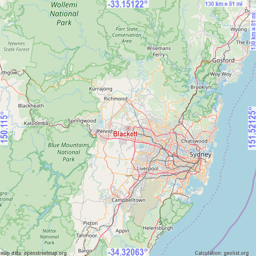
Blackett GPS coordinates[2]
33° 44' 16.512" South, 150° 49' 5.232" East
| Map corner | latitude | longitude |
|---|---|---|
| Upper-left | -33.15122°, | 150.115° |
| Center: | -33.73792°, | 150.81812° |
| Lower-right: | -34.32063°, | 151.52125° |
| Map W x H: | 130×130 km | = 80.8×80.8mi |
| max Lat: | -10.58257° ⇑49.8% North |
| Blackett: | -33.73792° |
| min Lat: | ⇓50.2% South -43.31423° |
| min Long | Blackett | max Long |
| 113.53327° | 150.81812° | 153.61246° |
| W 63%⇐ | ⇒37% E |
Elevation
Elevation of Blackett is 58 m = 190 ft, and this is 64 m = 210 ft below average elevation for this country.
| Max E: |
1715 m = 5627 ft | 42.6% |
| Avg. | 122 m = 400 ft | |
| Blackett | 58 m = 190 ft | |
Min E: |
-2 m = -7 ft | 57.4% |
See also: Australia elevation on elevation.city.
Geographical zone
Blackett is located in South temperate zone (between Tropic of Capricorn and the Antarctic Circle). Distance of this Southern Tropic circle is 1145.4 km =711.7 mi to North.| Distance of | km | miles | from Blackett |
|---|---|---|---|
| Equator | 3751.3 | 2330.9 | to North |
| Tropic Capricorn | 1145.4 | 711.7 | to North |
| Antarctic Circle | 3649.9 | 2267.9 | to South |
| South Pole | 6255.8 | 3887.2 | to South |


Nearby cities:
15 places around Blackett: (largest is in red/bold)
• Bidwill
0.9 km =0.6 mi,  23°
23°
• Colebee
2.9 km =1.8 mi,  67°
67°
• Dharruk
1.2 km =0.7 mi,  191°
191°
• Emerton
1.3 km =0.8 mi,  237°
237°
• Hassall Grove
1.7 km =1.1 mi, 72°
• Hebersham
1 km =0.6 mi,  148°
148°
• Lethbridge Park
1.6 km =1 mi,  272°
272°
• Mount Druitt
3.2 km =2 mi,  182°
182°
• Oakhurst
1.9 km =1.2 mi,  93°
93°
• Plumpton
2.3 km =1.4 mi,  131°
131°
• Ropes Crossing
2.6 km =1.6 mi,  282°
282°
• Shalvey
1.7 km =1.1 mi,  316°
316°
• Tregear
2.5 km =1.6 mi,  249°
249°
• Whalan
2.5 km =1.6 mi,  211°
211°
• Willmot
2.7 km =1.7 mi,  300°
300°
Sources, notices
• [Note1] Compared only with cities in Australia existing in our database
• [Src1] Map data: © OpenStreetMap contributors (CC-BY-SA)
• [Src2] Other city data from geonames.org with taken over terms of usage.
• [Src3] Geographical zone / Annual Mean Temperature by Robert A. Rohde @ Wikipedia
