Gregory Hills geodata
Gregory Hills (New South Wales) is a section of populated place; located in Australia in Australia/Sydney (GMT+11) time zone. With population of 4,968 people, there are 1484 cities with bigger population in this country. Compared to other cities in Australia, 59.5% of cities are located further ↑North; 61.8% of cities are located further ←West and 70.1% of cities have lower elevation than Gregory Hills. Note1


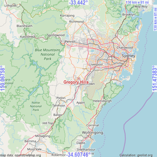
Gregory Hills GPS coordinates[2]
34° 1' 36.228" South, 150° 46' 14.52" East
| Map corner | latitude | longitude |
|---|---|---|
| Upper-left | -33.442°, | 150.06758° |
| Center: | -34.02673°, | 150.7707° |
| Lower-right: | -34.60746°, | 151.47383° |
| Map W x H: | 129.6×129.6 km | = 80.5×80.5mi |
| max Lat: | -10.58257° ⇑59.5% North |
| Gregory Hills: | -34.02673° |
| min Lat: | ⇓40.5% South -43.31423° |
| min Long | Gregory Hills | max Long |
| 113.53327° | 150.7707° | 153.61246° |
| W 61.8%⇐ | ⇒38.2% E |
Elevation
Elevation of Gregory Hills is 104 m = 341 ft, and this is 18 m = 59 ft below average elevation for this country.
| Max E: |
1715 m = 5627 ft | 29.9% |
| Avg. | 122 m = 400 ft | |
| Gregory Hills | 104 m = 341 ft | |
Min E: |
-2 m = -7 ft | 70.1% |
See also: Australia elevation on elevation.city.
Geographical zone
Gregory Hills is located in South temperate zone (between Tropic of Capricorn and the Antarctic Circle). Distance of this Southern Tropic circle is 1177.5 km =731.7 mi to North.| Distance of | km | miles | from Gregory Hills |
|---|---|---|---|
| Equator | 3783.4 | 2350.9 | to North |
| Tropic Capricorn | 1177.5 | 731.7 | to North |
| Antarctic Circle | 3617.8 | 2248 | to South |
| South Pole | 6223.6 | 3867.2 | to South |


Nearby cities:
15 places around Gregory Hills: (largest is in red/bold)
• Blair Athol
4.8 km =3 mi,  144°
144°
• Catherine Field
2.5 km =1.6 mi,  3°
3°
• Claymore
4.3 km =2.7 mi,  120°
120°
• Currans Hill
1.8 km =1.1 mi,  173°
173°
• Eagle Vale
4.1 km =2.5 mi,  106°
106°
• Eschol Park
3.6 km =2.2 mi,  95°
95°
• Harrington Park
3.3 km =2.1 mi,  275°
275°
• Kearns
2.8 km =1.7 mi,  79°
79°
• Mount Annan
3.1 km =1.9 mi,  198°
198°
• Narellan
4 km =2.5 mi,  242°
242°
• Narellan Vale
3.6 km =2.2 mi,  223°
223°
• Oran Park
3.7 km =2.3 mi,  309°
309°
• Raby
4.4 km =2.7 mi, 77°
• St Andrews
5.4 km =3.4 mi, 84°
• Woodbine
5.1 km =3.2 mi, 114°
Sources, notices
• [Note1] Compared only with cities in Australia existing in our database
• [Src1] Map data: © OpenStreetMap contributors (CC-BY-SA)
• [Src2] Other city data from geonames.org with taken over terms of usage.
• [Src3] Geographical zone / Annual Mean Temperature by Robert A. Rohde @ Wikipedia
