Millswood geodata
Millswood (South Australia) is a section of populated place; located in Australia in Australia/Adelaide (GMT+10.5) time zone. With population of 2,086 people, there are 2839 cities with bigger population in this country. Compared to other cities in Australia, 70.1% of cities are located further ↑North; 81.8% of cities are located further →East and 52.4% of cities have higher elevation than Millswood. Note1


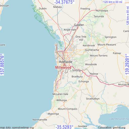
Millswood GPS coordinates[2]
34° 57' 18.18" South, 138° 35' 19.968" East
| Map corner | latitude | longitude |
|---|---|---|
| Upper-left | -34.37675°, | 137.88576° |
| Center: | -34.95505°, | 138.58888° |
| Lower-right: | -35.5293°, | 139.29201° |
| Map W x H: | 128.2×128.2 km | = 79.7×79.7mi |
| max Lat: | -10.58257° ⇑70.1% North |
| Millswood: | -34.95505° |
| min Lat: | ⇓29.9% South -43.31423° |
| min Long | Millswood | max Long |
| 113.53327° | 138.58888° | 153.61246° |
| W 18.2%⇐ | ⇒81.8% E |
Elevation
Elevation of Millswood is 42 m = 138 ft, and this is 80 m = 262 ft below average elevation for this country.
| Max E: |
1715 m = 5627 ft | 52.4% |
| Avg. | 122 m = 400 ft | |
| Millswood | 42 m = 138 ft | |
Min E: |
-2 m = -7 ft | 47.6% |
See also: Australia elevation on elevation.city.
Geographical zone
Millswood is located in South temperate zone (between Tropic of Capricorn and the Antarctic Circle). Distance of this Southern Tropic circle is 1280.7 km =795.8 mi to North.| Distance of | km | miles | from Millswood |
|---|---|---|---|
| Equator | 3886.6 | 2415 | to North |
| Tropic Capricorn | 1280.7 | 795.8 | to North |
| Antarctic Circle | 3514.5 | 2183.8 | to South |
| South Pole | 6120.4 | 3803 | to South |


Nearby cities:
15 places around Millswood: (largest is in red/bold)
• Ashford
1.5 km =0.9 mi,  298°
298°
• Black Forest
1.3 km =0.8 mi,  242°
242°
• Clarence Park
1.3 km =0.8 mi,  216°
216°
• Cumberland Park
1.9 km =1.2 mi,  186°
186°
• Everard Park
1.3 km =0.8 mi,  285°
285°
• Forestville
1.1 km =0.7 mi, 303°
• Glandore
2 km =1.2 mi,  248°
248°
• Goodwood
0.6 km =0.4 mi,  34°
34°
• Hyde Park
1.1 km =0.7 mi,  87°
87°
• Kings Park
1 km =0.6 mi,  169°
169°
• Kurralta Park
2 km =1.2 mi,  281°
281°
• Unley
1.2 km =0.7 mi,  61°
61°
• Unley Park
2 km =1.2 mi,  119°
119°
• Wayville
1.2 km =0.7 mi,  10°
10°
• Westbourne Park
1.9 km =1.2 mi,  162°
162°
Sources, notices
• [Note1] Compared only with cities in Australia existing in our database
• [Src1] Map data: © OpenStreetMap contributors (CC-BY-SA)
• [Src2] Other city data from geonames.org with taken over terms of usage.
• [Src3] Geographical zone / Annual Mean Temperature by Robert A. Rohde @ Wikipedia
