Kooyong geodata
Kooyong (Victoria) is a populated place; located in Australia in Australia/Melbourne (GMT+11) time zone. With population of 793 people, there are 4164 cities with bigger population in this country. Compared to other cities in Australia, 89% of cities are located further ↑North; 65.6% of cities are located further →East and 61.1% of cities have higher elevation than Kooyong. Note1


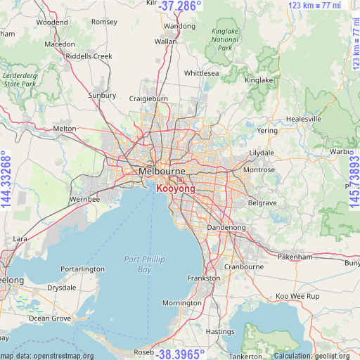
Kooyong GPS coordinates[2]
37° 50' 36.024" South, 145° 2' 8.88" East
| Map corner | latitude | longitude |
|---|---|---|
| Upper-left | -37.286°, | 144.33268° |
| Center: | -37.84334°, | 145.0358° |
| Lower-right: | -38.3965°, | 145.73893° |
| Map W x H: | 123.5×123.5 km | = 76.7×76.7mi |
| max Lat: | -10.58257° ⇑89% North |
| Kooyong: | -37.84334° |
| min Lat: | ⇓11% South -43.31423° |
| min Long | Kooyong | max Long |
| 113.53327° | 145.0358° | 153.61246° |
| W 34.4%⇐ | ⇒65.6% E |
Elevation
Elevation of Kooyong is 31 m = 102 ft, and this is 91 m = 299 ft below average elevation for this country.
| Max E: |
1715 m = 5627 ft | 61.1% |
| Avg. | 122 m = 400 ft | |
| Kooyong | 31 m = 102 ft | |
Min E: |
-2 m = -7 ft | 38.9% |
See also: Australia elevation on elevation.city.
Geographical zone
Kooyong is located in South temperate zone (between Tropic of Capricorn and the Antarctic Circle). Distance of this Southern Tropic circle is 1601.9 km =995.4 mi to North.| Distance of | km | miles | from Kooyong |
|---|---|---|---|
| Equator | 4207.8 | 2614.6 | to North |
| Tropic Capricorn | 1601.9 | 995.4 | to North |
| Antarctic Circle | 3193.4 | 1984.3 | to South |
| South Pole | 5799.3 | 3603.5 | to South |


Nearby cities:
15 places around Kooyong: (largest is in red/bold)
• Armadale
1.9 km =1.2 mi,  224°
224°
• Burnley
2.2 km =1.4 mi,  313°
313°
• Camberwell
3 km =1.9 mi,  87°
87°
• Caulfield North
3.5 km =2.2 mi,  195°
195°
• Cremorne
3.9 km =2.4 mi,  289°
289°
• Glen Iris
3.8 km =2.4 mi,  133°
133°
• Glenferrie
1.7 km =1.1 mi,  48°
48°
• Hawthorn
2.6 km =1.6 mi,  0°
0°
• Hawthorn East
2.3 km =1.4 mi,  24°
24°
• Hawthorn South
1.2 km =0.7 mi, 3°
• Malvern
2.2 km =1.4 mi, 197°
• Malvern East
3.5 km =2.2 mi,  170°
170°
• Prahran
3.8 km =2.4 mi,  256°
256°
• South Yarra
3.9 km =2.4 mi,  278°
278°
• Toorak
1.9 km =1.2 mi, 275°
Sources, notices
• [Note1] Compared only with cities in Australia existing in our database
• [Src1] Map data: © OpenStreetMap contributors (CC-BY-SA)
• [Src2] Other city data from geonames.org with taken over terms of usage.
• [Src3] Geographical zone / Annual Mean Temperature by Robert A. Rohde @ Wikipedia
