Cliftleigh geodata
Cliftleigh (New South Wales) is a populated place; located in Australia in Australia/Sydney (GMT+11) time zone. With population of 891 people, there are 3987 cities with bigger population in this country. Compared to other cities in Australia, 59.8% of cities are located further ↓South; 78% of cities are located further ←West and 65.9% of cities have higher elevation than Cliftleigh. Note1


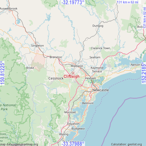
Cliftleigh GPS coordinates[2]
32° 47' 26.772" South, 151° 30' 55.332" East
| Map corner | latitude | longitude |
|---|---|---|
| Upper-left | -32.19773°, | 150.81225° |
| Center: | -32.79077°, | 151.51537° |
| Lower-right: | -33.37988°, | 152.2185° |
| Map W x H: | 131.4×131.4 km | = 81.6×81.6mi |
| max Lat: | -10.58257° ⇑40.2% North |
| Cliftleigh: | -32.79077° |
| min Lat: | ⇓59.8% South -43.31423° |
| min Long | Cliftleigh | max Long |
| 113.53327° | 151.51537° | 153.61246° |
| W 78%⇐ | ⇒22% E |
Elevation
Elevation of Cliftleigh is 26 m = 85 ft, and this is 96 m = 315 ft below average elevation for this country.
| Max E: |
1715 m = 5627 ft | 65.9% |
| Avg. | 122 m = 400 ft | |
| Cliftleigh | 26 m = 85 ft | |
Min E: |
-2 m = -7 ft | 34.1% |
See also: Australia elevation on elevation.city.
Geographical zone
Cliftleigh is located in South temperate zone (between Tropic of Capricorn and the Antarctic Circle). Distance of this Southern Tropic circle is 1040.1 km =646.3 mi to North.| Distance of | km | miles | from Cliftleigh |
|---|---|---|---|
| Equator | 3646 | 2265.5 | to North |
| Tropic Capricorn | 1040.1 | 646.3 | to North |
| Antarctic Circle | 3755.2 | 2333.4 | to South |
| South Pole | 6361.1 | 3952.6 | to South |


Nearby cities:
15 places around Cliftleigh: (largest is in red/bold)
• Abermain
8.4 km =5.2 mi,  257°
257°
• Ashtonfield
8.7 km =5.4 mi,  77°
77°
• East Maitland
7.8 km =4.8 mi,  54°
54°
• Gillieston Heights
3.5 km =2.2 mi,  20°
20°
• Heddon Greta
1.3 km =0.8 mi,  188°
188°
• Kurri Kurri
4.6 km =2.9 mi,  226°
226°
• Lorn
8.9 km =5.5 mi,  36°
36°
• Louth Park
3.8 km =2.4 mi, 54°
• Maitland
7.5 km =4.7 mi,  31°
31°
• Maitland city centre
7.4 km =4.6 mi, 28°
• Metford
9.2 km =5.7 mi,  71°
71°
• Pelaw Main
6.1 km =3.8 mi,  211°
211°
• Rutherford
8.4 km =5.2 mi,  11°
11°
• Stanford Merthyr
4.3 km =2.7 mi, 208°
• Telarah
7.1 km =4.4 mi, 14°
Sources, notices
• [Note1] Compared only with cities in Australia existing in our database
• [Src1] Map data: © OpenStreetMap contributors (CC-BY-SA)
• [Src2] Other city data from geonames.org with taken over terms of usage.
• [Src3] Geographical zone / Annual Mean Temperature by Robert A. Rohde @ Wikipedia
