Brändö geodata
Brändö (Ålands skärgård) is a seat of a second-order administrative division; located in Aland Islands in Europe/Mariehamn (GMT+3) time zone. With population of 515 people, there are 9 cities with bigger population in this country. Compared to other cities in Aland Islands, 100% of cities are located further ↓South; 100% of cities are located further ←West and 60% of cities have higher elevation than Brändö. Note1


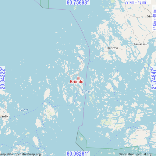
Brändö GPS coordinates[2]
60° 24' 41.94" North, 21° 2' 43.224" East
| Map corner | latitude | longitude |
|---|---|---|
| Upper-left | 60.75698°, | 20.34222° |
| Center: | 60.41165°, | 21.04534° |
| Lower-right: | 60.06261°, | 21.74847° |
| Map W x H: | 77.2×77.2 km | = 48×48mi |
| max Lat: | 60.41165° ⇑0% North |
| Brändö: | 60.41165° |
| min Lat: | ⇓100% South 59.92051° |
| min Long | Brändö | max Long |
| 19.61442° | 21.04534° | 21.04534° |
| W 100%⇐ | ⇒0% E |
Elevation
Elevation of Brändö is 10 m = 33 ft, and this is 3.1 m = 10 ft below average elevation for this country.
| Max E: |
42 m = 138 ft | 60% |
| Avg. | 13.1 m = 43 ft | |
| Brändö | 10 m = 33 ft | |
Min E: |
3 m = 10 ft | 40% |
See also: Aland Islands elevation on elevation.city.
Geographical zone
Brändö is located in North temperate zone (between Tropic of Cancer and the Arctic Circle). Distance of this North polar circle is 684 km =425 mi to North.| Distance of | km | miles | from Brändö |
|---|---|---|---|
| North Pole | 3289.9 | 2044.2 | to North |
| Arctic Circle | 684 | 425 | to North |
| Tropic Cancer | 4111.2 | 2554.6 | to South |
| Equator | 6717.1 | 4173.8 | to South |


Nearby cities:
15 places around Brändö: (largest is in red/bold)
• Eckerö
81.9 km =50.9 mi,  254°
254°
• Finström
63.3 km =39.3 mi,  255°
255°
• Föglö
56 km =34.8 mi,  218°
218°
• Geta
66.1 km =41.1 mi,  266°
266°
• Hammarland
74.5 km =46.3 mi, 253°
• Jomala
67 km =41.6 mi,  244°
244°
• Kumlinge
22.3 km =13.9 mi, 221°
• Kökar
55.1 km =34.2 mi,  187°
187°
• Lemland
65.1 km =40.5 mi,  234°
234°
• Lumparland
54.4 km =33.8 mi, 232°
• Mariehamn
70.5 km =43.8 mi, 240°
• Saltvik
56.6 km =35.2 mi, 255°
• Sottunga
37.6 km =23.4 mi,  213°
213°
• Sund
54.2 km =33.7 mi, 250°
• Vårdö
40.6 km =25.2 mi, 243°
Sources, notices
• [Note1] Compared only with cities in Aland Islands existing in our database
• [Src1] Map data: © OpenStreetMap contributors (CC-BY-SA)
• [Src2] Other city data from geonames.org with taken over terms of usage.
• [Src3] Geographical zone / Annual Mean Temperature by Robert A. Rohde @ Wikipedia
