Varoška Rijeka geodata
Varoška Rijeka (Federation of B&H) is a populated locality; located in Bosnia and Herzegovina in Europe/Sarajevo (GMT+2) time zone. With population of 6,573 people, there are 80 cities with bigger population in this country. Compared to other cities in Bosnia and Herzegovina, 95.1% of cities are located further ↓South; 93.2% of cities are located further →East and 71.7% of cities have higher elevation than Varoška Rijeka. Note1


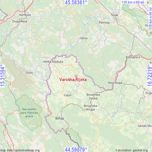
Varoška Rijeka GPS coordinates[2]
45° 5' 21.696" North, 16° 1' 8.616" East
| Map corner | latitude | longitude |
|---|---|---|
| Upper-left | 45.58361°, | 15.31594° |
| Center: | 45.08936°, | 16.01906° |
| Lower-right: | 44.59079°, | 16.72219° |
| Map W x H: | 110.4×110.4 km | = 68.6×68.6mi |
| max Lat: | 45.21956° ⇑4.9% North |
| Varoška Rijeka: | 45.08936° |
| min Lat: | ⇓95.1% South 42.71197° |
| min Long | Varoška Rijeka | max Long |
| 15.77806° | 16.01906° | 19.36719° |
| W 6.8%⇐ | ⇒93.2% E |
Elevation
Elevation of Varoška Rijeka is 193 m = 633 ft, and this is 166.5 m = 546 ft below average elevation for this country.
| Max E: |
1175 m = 3855 ft | 71.7% |
| Avg. | 359.5 m = 1179 ft | |
| Varoška Rijeka | 193 m = 633 ft | |
Min E: |
17 m = 56 ft | 28.3% |
See also: Bosnia and Herzegovina elevation on elevation.city.
Geographical zone
Varoška Rijeka is located in North temperate zone (between Tropic of Cancer and the Arctic Circle). Distance of this North polar circle is 2387.7 km =1483.6 mi to North.| Distance of | km | miles | from Varoška Rijeka |
|---|---|---|---|
| North Pole | 4993.6 | 3102.9 | to North |
| Arctic Circle | 2387.7 | 1483.6 | to North |
| Tropic Cancer | 2407.5 | 1496 | to South |
| Equator | 5013.5 | 3115.2 | to South |


Nearby cities:
15 places around Varoška Rijeka: (largest is in red/bold)
• Bužim
4.1 km =2.5 mi,  165°
165°
• Cazin
14.9 km =9.3 mi,  203°
203°
• Gornja Koprivna
10.1 km =6.3 mi,  210°
210°
• Jezerski
13.4 km =8.3 mi,  153°
153°
• Mala Kladuša
14 km =8.7 mi,  290°
290°
• Otoka
19.1 km =11.9 mi,  138°
138°
• Pećigrad
10.3 km =6.4 mi,  247°
247°
• Podzvizd
14.8 km =9.2 mi,  309°
309°
• Skokovi
10.4 km =6.5 mi,  231°
231°
• Stijena
17 km =10.6 mi,  179°
179°
• Todorovo
6.9 km =4.3 mi,  269°
269°
• Vrnograč
9.7 km =6 mi,  328°
328°
• Zborište
6.3 km =3.9 mi,  358°
358°
• Ćoralići
14.7 km =9.1 mi, 231°
• Šumatac
12.7 km =7.9 mi, 274°
Sources, notices
• [Note1] Compared only with cities in Bosnia and Herzegovina existing in our database
• [Src1] Map data: © OpenStreetMap contributors (CC-BY-SA)
• [Src2] Other city data from geonames.org with taken over terms of usage.
• [Src3] Geographical zone / Annual Mean Temperature by Robert A. Rohde @ Wikipedia
