Donja Mahala geodata
Donja Mahala (Federation of B&H) is a populated place; located in Bosnia and Herzegovina in Europe/Sarajevo (GMT+2) time zone. With population of 5,565 people, there are 103 cities with bigger population in this country. Compared to other cities in Bosnia and Herzegovina, 91.7% of cities are located further ↓South; 82.3% of cities are located further ←West and 95.8% of cities have higher elevation than Donja Mahala. Note1


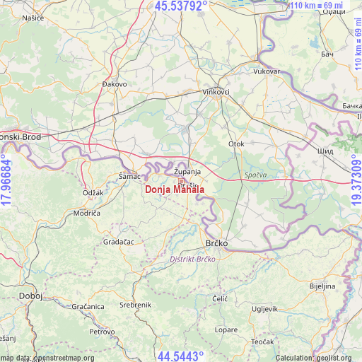
Donja Mahala GPS coordinates[2]
45° 2' 35.772" North, 18° 40' 11.856" East
| Map corner | latitude | longitude |
|---|---|---|
| Upper-left | 45.53792°, | 17.96684° |
| Center: | 45.04327°, | 18.66996° |
| Lower-right: | 44.5443°, | 19.37309° |
| Map W x H: | 110.5×110.5 km | = 68.7×68.7mi |
| max Lat: | 45.21956° ⇑8.3% North |
| Donja Mahala: | 45.04327° |
| min Lat: | ⇓91.7% South 42.71197° |
| min Long | Donja Mahala | max Long |
| 15.77806° | 18.66996° | 19.36719° |
| W 82.3%⇐ | ⇒17.7% E |
Elevation
Elevation of Donja Mahala is 84 m = 276 ft, and this is 275.5 m = 904 ft below average elevation for this country.
| Max E: |
1175 m = 3855 ft | 95.8% |
| Avg. | 359.5 m = 1179 ft | |
| Donja Mahala | 84 m = 276 ft | |
Min E: |
17 m = 56 ft | 4.2% |
See also: Bosnia and Herzegovina elevation on elevation.city.
Geographical zone
Donja Mahala is located in North temperate zone (between Tropic of Cancer and the Arctic Circle). Distance of this North polar circle is 2392.8 km =1486.8 mi to North.| Distance of | km | miles | from Donja Mahala |
|---|---|---|---|
| North Pole | 4998.7 | 3106 | to North |
| Arctic Circle | 2392.8 | 1486.8 | to North |
| Tropic Cancer | 2402.4 | 1492.8 | to South |
| Equator | 5008.3 | 3112 | to South |


Nearby cities:
15 places around Donja Mahala: (largest is in red/bold)
• Brka
24.3 km =15.1 mi,  169°
169°
• Brčko
22.2 km =13.8 mi,  150°
150°
• Domaljevac
6.9 km =4.3 mi,  286°
286°
• Donja Dubica
20.7 km =12.9 mi,  279°
279°
• Donja Međiđa
34 km =21.1 mi,  217°
217°
• Donji Žabar
11.3 km =7 mi,  189°
189°
• Gradačac
26.4 km =16.4 mi,  226°
226°
• Mionica
25.4 km =15.8 mi, 219°
• Obudovac
11.6 km =7.2 mi,  208°
208°
• Odžak
27.5 km =17.1 mi,  265°
265°
• Orašje
2.1 km =1.3 mi,  120°
120°
• Oštra Luka
8.4 km =5.2 mi, 232°
• Pelagićevo
17 km =10.6 mi,  201°
201°
• Čelić
37.2 km =23.1 mi,  162°
162°
• Šamac
16 km =9.9 mi, 276°
Sources, notices
• [Note1] Compared only with cities in Bosnia and Herzegovina existing in our database
• [Src1] Map data: © OpenStreetMap contributors (CC-BY-SA)
• [Src2] Other city data from geonames.org with taken over terms of usage.
• [Src3] Geographical zone / Annual Mean Temperature by Robert A. Rohde @ Wikipedia
