Aubange geodata
Aubange (Wallonia) is a populated place; located in Belgium in Europe/Brussels (GMT+2) time zone. With population of 14,932 people, there are 184 cities with bigger population in this country. Compared to other cities in Belgium, 99.6% of cities are located further ↑North; 94.9% of cities are located further ←West and 91.5% of cities have lower elevation than Aubange. Note1
Administrative division(s):
- Level 1: Wallonia
- Level 2: Province du Luxembourg
- Level 3: Arrondissement d'Arlon
- Level 4: Aubange


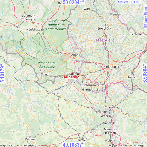
Aubange GPS coordinates[2]
49° 33' 59.472" North, 5° 48' 17.712" East
| Map corner | latitude | longitude |
|---|---|---|
| Upper-left | 50.02041°, | 5.10179° |
| Center: | 49.56652°, | 5.80492° |
| Lower-right: | 49.10837°, | 6.50804° |
| Map W x H: | 101.4×101.4 km | = 63×63mi |
| max Lat: | 51.46791° ⇑99.6% North |
| Aubange: | 49.56652° |
| min Lat: | ⇓0.4% South 49.53771° |
| min Long | Aubange | max Long |
| 2.59368° | 5.80492° | 6.25749° |
| W 94.9%⇐ | ⇒5.1% E |
Elevation
Elevation of Aubange is 278 m = 912 ft, and this is 178.5 m = 586 ft above average elevation for this country.
| Max E: |
582 m = 1909 ft | 8.5% |
| Aubange | 278 m 912 ft | |
| Avg. | 99.5 m = 326 ft | |
Min E: |
1 m = 3 ft | 91.5% |
See also: Belgium elevation on elevation.city.
Geographical zone
Aubange is located in North temperate zone (between Tropic of Cancer and the Arctic Circle). Distance of this North polar circle is 1889.9 km =1174.3 mi to North.| Distance of | km | miles | from Aubange |
|---|---|---|---|
| North Pole | 4495.8 | 2793.6 | to North |
| Arctic Circle | 1889.9 | 1174.3 | to North |
| Tropic Cancer | 2905.4 | 1805.3 | to South |
| Equator | 5511.3 | 3424.6 | to South |


Nearby cities:
15 places around Aubange: (largest is in red/bold)
• Arlon
13 km =8.1 mi,  3°
3°
• Attert
20.5 km =12.7 mi,  356°
356°
• Chiny
38.5 km =23.9 mi,  299°
299°
• Fauvillers
33.2 km =20.6 mi,  342°
342°
• Habay-la-Vieille
21.9 km =13.6 mi,  322°
322°
• Léglise
32.3 km =20.1 mi, 323°
• Martelange
29.9 km =18.6 mi,  350°
350°
• Meix-devant-Virton
23.8 km =14.8 mi,  280°
280°
• Messancy
3 km =1.9 mi,  19°
19°
• Musson
7.2 km =4.5 mi,  262°
262°
• Rouvroy
22.9 km =14.2 mi, 261°
• Saint-Léger
11.8 km =7.3 mi, 295°
• Tintigny
24.7 km =15.3 mi, 301°
• Virton
19.6 km =12.2 mi,  270°
270°
• Étalle
19 km =11.8 mi,  308°
308°
Sources, notices
• [Note1] Compared only with cities in Belgium existing in our database
• [Src1] Map data: © OpenStreetMap contributors (CC-BY-SA)
• [Src2] Other city data from geonames.org with taken over terms of usage.
• [Src3] Geographical zone / Annual Mean Temperature by Robert A. Rohde @ Wikipedia
