Vidin geodata
Vidin is a seat of a first-order administrative division; located in Bulgaria in Europe/Sofia (GMT+3) time zone. With population of 54,409 people, there are 19 cities with bigger population in this country. Compared to other cities in Bulgaria, 98% of cities are located further ↓South; 94.7% of cities are located further →East and 91% of cities have higher elevation than Vidin. Note1


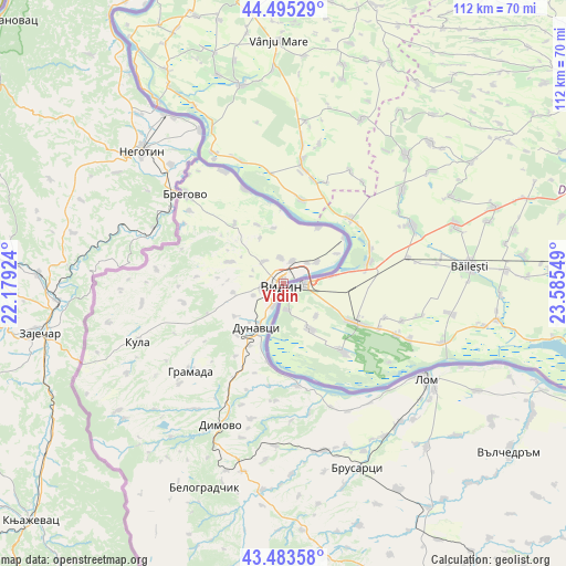
Vidin GPS coordinates[2]
43° 59' 29.724" North, 22° 52' 56.496" East
| Map corner | latitude | longitude |
|---|---|---|
| Upper-left | 44.49529°, | 22.17924° |
| Center: | 43.99159°, | 22.88236° |
| Lower-right: | 43.48358°, | 23.58549° |
| Map W x H: | 112.5×112.5 km | = 69.9×69.9mi |
| max Lat: | 44.16214° ⇑2% North |
| Vidin: | 43.99159° |
| min Lat: | ⇓98% South 41.32715° |
| min Long | Vidin | max Long |
| 22.52139° | 22.88236° | 28.53429° |
| W 5.3%⇐ | ⇒94.7% E |
Elevation
Elevation of Vidin is 35 m = 115 ft, and this is 281.6 m = 924 ft below average elevation for this country.
| Max E: |
1221 m = 4006 ft | 91% |
| Avg. | 316.6 m = 1039 ft | |
| Vidin | 35 m = 115 ft | |
Min E: |
1 m = 3 ft | 9% |
See also: Vidin elevation on elevation.city.
Geographical zone
Vidin is located in North temperate zone (between Tropic of Cancer and the Arctic Circle). Distance of this Northern Tropic circle is 2285.5 km =1420.1 mi to South.| Distance of | km | miles | from Vidin |
|---|---|---|---|
| North Pole | 5115.7 | 3178.7 | to North |
| Arctic Circle | 2509.8 | 1559.5 | to North |
| Tropic Cancer | 2285.5 | 1420.1 | to South |
| Equator | 4891.4 | 3039.4 | to South |


Nearby cities:
15 places around Vidin: (largest is in red/bold)
• Belogradchik
43.5 km =27 mi,  201°
201°
• Boynitsa
28.3 km =17.6 mi,  262°
262°
• Bregovo
26.2 km =16.3 mi,  312°
312°
• Brusartsi
39.7 km =24.7 mi,  158°
158°
• Dimovo
30.5 km =19 mi, 204°
• Drenovets
34.2 km =21.3 mi,  167°
167°
• Dunavtsi
9.2 km =5.7 mi,  212°
212°
• Gramada
25.1 km =15.6 mi,  227°
227°
• Kula
31.1 km =19.3 mi,  248°
248°
• Lom
34.1 km =21.2 mi,  123°
123°
• Makresh
30.4 km =18.9 mi,  215°
215°
• Medkovets
46.9 km =29.1 mi,  150°
150°
• Novo Selo
20.5 km =12.7 mi,  337°
337°
• Ruzhintsi
41.3 km =25.7 mi,  185°
185°
• Yakimovo
54.8 km =34.1 mi,  136°
136°
Sources, notices
• [Note1] Compared only with cities in Bulgaria existing in our database
• [Src1] Map data: © OpenStreetMap contributors (CC-BY-SA)
• [Src2] Other city data from geonames.org with taken over terms of usage.
• [Src3] Geographical zone / Annual Mean Temperature by Robert A. Rohde @ Wikipedia
