Botevgrad geodata
Botevgrad (Sofia) is a populated place; located in Bulgaria in Europe/Sofia (GMT+3) time zone. With population of 20,909 people, there are 43 cities with bigger population in this country. Compared to other cities in Bulgaria, 53% of cities are located further ↓South; 75.7% of cities are located further →East and 67% of cities have lower elevation than Botevgrad. Note1


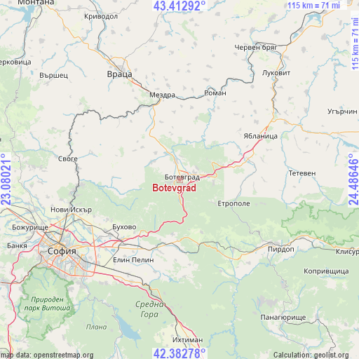
Botevgrad GPS coordinates[2]
42° 54' 0" North, 23° 46' 59.988" East
| Map corner | latitude | longitude |
|---|---|---|
| Upper-left | 43.41292°, | 23.08021° |
| Center: | 42.9°, | 23.78333° |
| Lower-right: | 42.38278°, | 24.48646° |
| Map W x H: | 114.5×114.5 km | = 71.1×71.1mi |
| max Lat: | 44.16214° ⇑47% North |
| Botevgrad: | 42.9° |
| min Lat: | ⇓53% South 41.32715° |
| min Long | Botevgrad | max Long |
| 22.52139° | 23.78333° | 28.53429° |
| W 24.3%⇐ | ⇒75.7% E |
Elevation
Elevation of Botevgrad is 363 m = 1191 ft, and this is 46.4 m = 152 ft above average elevation for this country.
| Max E: |
1221 m = 4006 ft | 33% |
| Botevgrad | 363 m 1191 ft | |
| Avg. | 316.6 m = 1039 ft | |
Min E: |
1 m = 3 ft | 67% |
See also: Bulgaria elevation on elevation.city.
Geographical zone
Botevgrad is located in North temperate zone (between Tropic of Cancer and the Arctic Circle). Distance of this Northern Tropic circle is 2164.1 km =1344.7 mi to South.| Distance of | km | miles | from Botevgrad |
|---|---|---|---|
| North Pole | 5237 | 3254.1 | to North |
| Arctic Circle | 2631.1 | 1634.9 | to North |
| Tropic Cancer | 2164.1 | 1344.7 | to South |
| Equator | 4770 | 2963.9 | to South |


Nearby cities:
15 places around Botevgrad: (largest is in red/bold)
• Bov
36.1 km =22.4 mi,  294°
294°
• Buhovo
23.1 km =14.4 mi,  229°
229°
• Chavdar
35.3 km =21.9 mi,  141°
141°
• Chelopech
33.1 km =20.6 mi,  132°
132°
• Elin Pelin
29.9 km =18.6 mi,  209°
209°
• Etropole
19.2 km =11.9 mi,  112°
112°
• Gorna Malina
25 km =15.5 mi,  195°
195°
• Lakatnik
35.4 km =22 mi,  298°
298°
• Mezdra
28.6 km =17.8 mi,  346°
346°
• Mirkovo
27.6 km =17.1 mi, 143°
• Pravets
11 km =6.8 mi,  99°
99°
• Roman
29.8 km =18.5 mi,  21°
21°
• Svoge
36 km =22.4 mi,  281°
281°
• Yablanitsa
30.5 km =19 mi,  61°
61°
• Zlatitsa
35.1 km =21.8 mi, 125°
Sources, notices
• [Note1] Compared only with cities in Bulgaria existing in our database
• [Src1] Map data: © OpenStreetMap contributors (CC-BY-SA)
• [Src2] Other city data from geonames.org with taken over terms of usage.
• [Src3] Geographical zone / Annual Mean Temperature by Robert A. Rohde @ Wikipedia
