Gustavia geodata
Gustavia is a capital of a political entity; located in Saint Barthelemy in America/St_Barthelemy (GMT-4) time zone. With population of 5,988 people, there are 0 cities with bigger population in this country. Note1


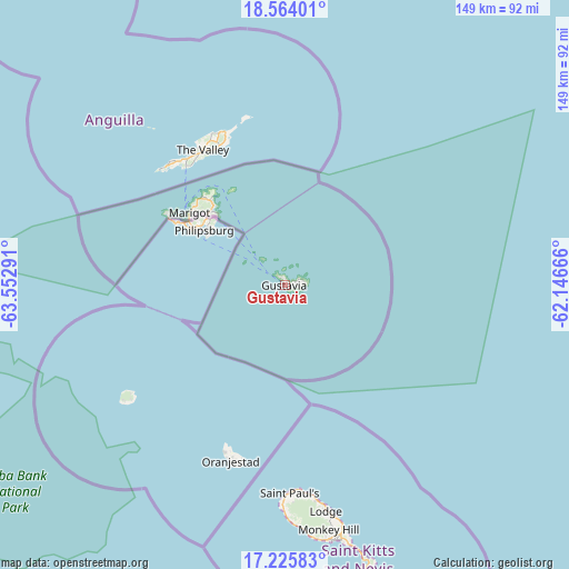
Gustavia GPS coordinates[2]
17° 53' 46.248" North, 62° 50' 59.208" West
| Map corner | latitude | longitude |
|---|---|---|
| Upper-left | 18.56401°, | -63.55291° |
| Center: | 17.89618°, | -62.84978° |
| Lower-right: | 17.22583°, | -62.14666° |
| Map W x H: | 148.8×148.8 km | = 92.5×92.5mi |
Elevation
Elevation of Gustavia is 6 m = 20 ft, and this is 0 m = 0 ft above average elevation for this country.
See also: Saint Barthelemy elevation on elevation.city.
Geographical zone
Gustavia is located in North Torrid zone (between Equator and Tropic of Cancer). Distance of this Northern Tropic circle is 616.1 km =382.8 mi to North.| Distance of | km | miles | from Gustavia |
|---|---|---|---|
| North Pole | 8017.2 | 4981.7 | to North |
| Arctic Circle | 5411.3 | 3362.4 | to North |
| Tropic Cancer | 616.1 | 382.8 | to North |
| Equator | 1989.9 | 1236.5 | to South |


Nearby cities:
0 places around Gustavia: (largest is in red/bold)
There is no such city in our database.
Sources, notices
• [Note1] Compared only with cities in Saint Barthelemy existing in our database
• [Src1] Map data: © OpenStreetMap contributors (CC-BY-SA)
• [Src2] Other city data from geonames.org with taken over terms of usage.
• [Src3] Geographical zone / Annual Mean Temperature by Robert A. Rohde @ Wikipedia
