San Matías geodata
San Matías (Santa Cruz) is a populated place; located in Bolivia in America/La_Paz (GMT-4) time zone. With population of 6,352 people, there are 54 cities with bigger population in this country. Compared to other cities in Bolivia, 82% of cities are located further ↓South; 99.4% of cities are located further ←West and 99.4% of cities have higher elevation than San Matías. Note1
Administrative division(s):
- Level 1: Santa Cruz
- Level 2: Provincia Ángel Sandoval
- Level 3: San Matias Municipality


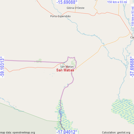
San Matías GPS coordinates[2]
16° 22' 0.012" South, 58° 24' 0" West
| Map corner | latitude | longitude |
|---|---|---|
| Upper-left | -15.69088°, | -59.10313° |
| Center: | -16.36667°, | -58.4° |
| Lower-right: | -17.04012°, | -57.69688° |
| Map W x H: | 150×150 km | = 93.2×93.2mi |
| max Lat: | -9.71828° ⇑18% North |
| San Matías: | -16.36667° |
| min Lat: | ⇓82% South -22.73206° |
| min Long | San Matías | max Long |
| -69.14843° | -58.4° | -57.76667° |
| W 99.4%⇐ | ⇒0.59999999999999% E |
Elevation
Elevation of San Matías is 120 m = 394 ft, and this is 1891.3 m = 6205 ft below average elevation for this country.
| Max E: |
4732 m = 15525 ft | 99.4% |
| Avg. | 2011.3 m = 6599 ft | |
| San Matías | 120 m = 394 ft | |
Min E: |
92 m = 302 ft | 0.6% |
See also: Bolivia elevation on elevation.city.
Geographical zone
San Matías is located in South Torrid zone (between Equator and Tropic of Capricorn). Distance of this Southern Tropic circle is 786.1 km =488.5 mi to South.| Distance of | km | miles | from San Matías |
|---|---|---|---|
| Equator | 1819.8 | 1130.8 | to North |
| Tropic Capricorn | 786.1 | 488.5 | to South |
| Antarctic Circle | 5581.4 | 3468.1 | to South |
| South Pole | 8187.3 | 5087.4 | to South |


Nearby cities:
5 places around San Matías: (largest is in red/bold)
• Concepción
266.8 km =165.8 mi,  268°
268°
• Puerto Quijarro
171.3 km =106.4 mi,  156°
156°
• Roboré
262.2 km =162.9 mi,  213°
213°
• San Ignacio de Velasco
272 km =169 mi, 270°
• San Pedro
260.8 km =162.1 mi,  215°
215°
Sources, notices
• [Note1] Compared only with cities in Bolivia existing in our database
• [Src1] Map data: © OpenStreetMap contributors (CC-BY-SA)
• [Src2] Other city data from geonames.org with taken over terms of usage.
• [Src3] Geographical zone / Annual Mean Temperature by Robert A. Rohde @ Wikipedia
