Rio Tavares geodata
Rio Tavares (Santa Catarina) is a populated locality; located in Brazil in America/Sao_Paulo (GMT-3) time zone. With population of 2,600 people, there are 1999 cities with bigger population in this country. Compared to other cities in Brazil, 93% of cities are located further ↑North; 66.8% of cities are located further →East and 91.7% of cities have higher elevation than Rio Tavares. Note1


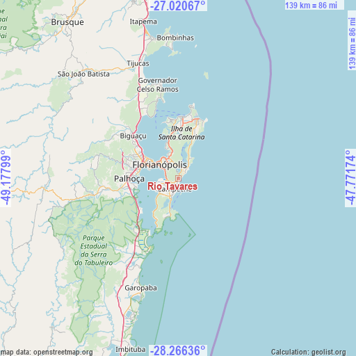
Rio Tavares GPS coordinates[2]
27° 38' 43.044" South, 48° 28' 29.496" West
| Map corner | latitude | longitude |
|---|---|---|
| Upper-left | -27.02067°, | -49.17799° |
| Center: | -27.64529°, | -48.47486° |
| Lower-right: | -28.26636°, | -47.77174° |
| Map W x H: | 138.5×138.5 km | = 86.1×86.1mi |
| max Lat: | 2.81972° ⇑93% North |
| Rio Tavares: | -27.64529° |
| min Lat: | ⇓7% South -33.69111° |
| min Long | Rio Tavares | max Long |
| -72.89583° | -48.47486° | -32.41083° |
| W 33.2%⇐ | ⇒66.8% E |
Elevation
Elevation of Rio Tavares is 14 m = 46 ft, and this is 366.9 m = 1204 ft below average elevation for this country.
| Max E: |
1603 m = 5259 ft | 91.7% |
| Avg. | 380.9 m = 1250 ft | |
| Rio Tavares | 14 m = 46 ft | |
Min E: |
0 m = 0 ft | 8.3% |
See also: Brazil elevation on elevation.city.
Geographical zone
Rio Tavares is located in South temperate zone (between Tropic of Capricorn and the Antarctic Circle). Distance of this Southern Tropic circle is 467.9 km =290.7 mi to North.| Distance of | km | miles | from Rio Tavares |
|---|---|---|---|
| Equator | 3073.9 | 1910 | to North |
| Tropic Capricorn | 467.9 | 290.7 | to North |
| Antarctic Circle | 4327.3 | 2688.9 | to South |
| South Pole | 6933.2 | 4308.1 | to South |


Nearby cities:
15 places around Rio Tavares: (largest is in red/bold)
• Carianos
6.9 km =4.3 mi,  255°
255°
• Carvoeira
7.2 km =4.5 mi,  315°
315°
• Corrego Grande
5.8 km =3.6 mi,  327°
327°
• Costeira do Pirajubae
4.7 km =2.9 mi,  282°
282°
• Florianópolis
9.1 km =5.7 mi,  306°
306°
• Freguesia do Ribeirao da Ilha
11.8 km =7.3 mi,  227°
227°
• Itacorubi
7.2 km =4.5 mi,  343°
343°
• Lagoa
4.6 km =2.9 mi,  9°
9°
• Morro da Cruz
9 km =5.6 mi, 318°
• Pantanal
5.7 km =3.5 mi, 313°
• Ribeirão da Ilha
8.2 km =5.1 mi,  223°
223°
• Saco dos Limoes
7.3 km =4.5 mi,  304°
304°
• Santa Monica
6.8 km =4.2 mi, 331°
• Tapera
8.7 km =5.4 mi,  239°
239°
• Trindade
8.1 km =5 mi, 324°
Sources, notices
• [Note1] Compared only with cities in Brazil existing in our database
• [Src1] Map data: © OpenStreetMap contributors (CC-BY-SA)
• [Src2] Other city data from geonames.org with taken over terms of usage.
• [Src3] Geographical zone / Annual Mean Temperature by Robert A. Rohde @ Wikipedia
