Penedo geodata
Penedo (Alagoas) is a populated place; located in Brazil in America/Maceio (GMT-3) time zone. With population of 42,097 people, there are 500 cities with bigger population in this country. Compared to other cities in Brazil, 67.1% of cities are located further ↓South; 90.5% of cities are located further ←West and 93.2% of cities have higher elevation than Penedo. Note1


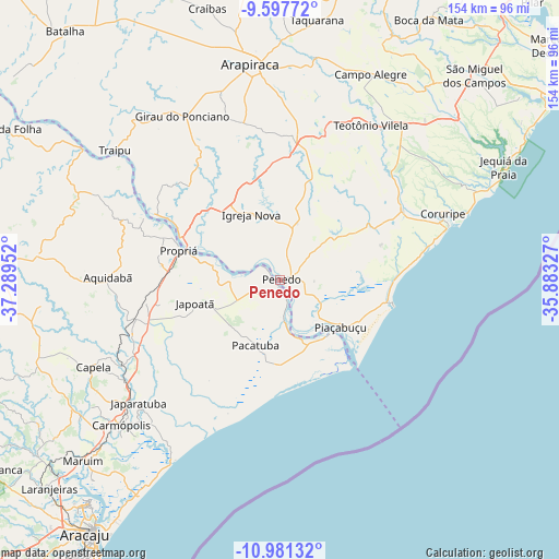
Penedo GPS coordinates[2]
10° 17' 25.008" South, 36° 35' 11.004" West
| Map corner | latitude | longitude |
|---|---|---|
| Upper-left | -9.59772°, | -37.28952° |
| Center: | -10.29028°, | -36.58639° |
| Lower-right: | -10.98132°, | -35.88327° |
| Map W x H: | 153.8×153.8 km | = 95.6×95.6mi |
| max Lat: | 2.81972° ⇑32.9% North |
| Penedo: | -10.29028° |
| min Lat: | ⇓67.1% South -33.69111° |
| min Long | Penedo | max Long |
| -72.89583° | -36.58639° | -32.41083° |
| W 90.5%⇐ | ⇒9.5% E |
Elevation
Elevation of Penedo is 12 m = 39 ft, and this is 368.9 m = 1210 ft below average elevation for this country.
| Max E: |
1603 m = 5259 ft | 93.2% |
| Avg. | 380.9 m = 1250 ft | |
| Penedo | 12 m = 39 ft | |
Min E: |
0 m = 0 ft | 6.8% |
See also: Penedo elevation on elevation.city.
Geographical zone
Penedo is located in South Torrid zone (between Equator and Tropic of Capricorn). Distance of Equator is 1144.2 km =711 mi to North.| Distance of | km | miles | from Penedo |
|---|---|---|---|
| Equator | 1144.2 | 711 | to North |
| Tropic Capricorn | 1461.7 | 908.3 | to South |
| Antarctic Circle | 6257 | 3887.9 | to South |
| South Pole | 8862.9 | 5507.1 | to South |


Nearby cities:
15 places around Penedo: (largest is in red/bold)
• Aquidabã
47.3 km =29.4 mi,  271°
271°
• Campo Grande
11.4 km =7.1 mi,  56°
56°
• Coruripe
48.5 km =30.1 mi,  67°
67°
• Girau do Ponciano
52.4 km =32.6 mi,  329°
329°
• Igreja Nova
20.1 km =12.5 mi,  335°
335°
• Japaratuba
51.3 km =31.9 mi,  228°
228°
• Japoatã
24.3 km =15.1 mi,  255°
255°
• Junqueiro
42.4 km =26.3 mi,  16°
16°
• Lagoa da Canoa
53.8 km =33.4 mi, 342°
• Neópolis
3.4 km =2.1 mi,  167°
167°
• Pacatuba
19.5 km =12.1 mi,  201°
201°
• Piaçabuçu
21 km =13 mi,  127°
127°
• Porto Real do Colégio
30.1 km =18.7 mi,  292°
292°
• Propriá
29.1 km =18.1 mi, 287°
• São Sebastião
39.8 km =24.7 mi,  5°
5°
Sources, notices
• [Note1] Compared only with cities in Brazil existing in our database
• [Src1] Map data: © OpenStreetMap contributors (CC-BY-SA)
• [Src2] Other city data from geonames.org with taken over terms of usage.
• [Src3] Geographical zone / Annual Mean Temperature by Robert A. Rohde @ Wikipedia
