Biguaçu geodata
Biguaçu (Santa Catarina) is a populated place; located in Brazil in America/Sao_Paulo (GMT-3) time zone. With population of 51,992 people, there are 415 cities with bigger population in this country. Compared to other cities in Brazil, 92.1% of cities are located further ↑North; 69.2% of cities are located further →East and 98.3% of cities have higher elevation than Biguaçu. Note1


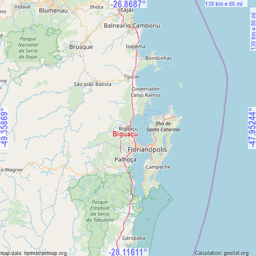
Biguaçu GPS coordinates[2]
27° 29' 39.012" South, 48° 39' 20.016" West
| Map corner | latitude | longitude |
|---|---|---|
| Upper-left | -26.8687°, | -49.35869° |
| Center: | -27.49417°, | -48.65556° |
| Lower-right: | -28.11611°, | -47.95244° |
| Map W x H: | 138.7×138.7 km | = 86.2×86.2mi |
| max Lat: | 2.81972° ⇑92.1% North |
| Biguaçu: | -27.49417° |
| min Lat: | ⇓7.9% South -33.69111° |
| min Long | Biguaçu | max Long |
| -72.89583° | -48.65556° | -32.41083° |
| W 30.8%⇐ | ⇒69.2% E |
Elevation
Elevation of Biguaçu is 6 m = 20 ft, and this is 374.9 m = 1230 ft below average elevation for this country.
| Max E: |
1603 m = 5259 ft | 98.3% |
| Avg. | 380.9 m = 1250 ft | |
| Biguaçu | 6 m = 20 ft | |
Min E: |
0 m = 0 ft | 1.7% |
See also: Biguaçu elevation on elevation.city.
Geographical zone
Biguaçu is located in South temperate zone (between Tropic of Capricorn and the Antarctic Circle). Distance of this Southern Tropic circle is 451.1 km =280.3 mi to North.| Distance of | km | miles | from Biguaçu |
|---|---|---|---|
| Equator | 3057.1 | 1899.6 | to North |
| Tropic Capricorn | 451.1 | 280.3 | to North |
| Antarctic Circle | 4344.1 | 2699.3 | to South |
| South Pole | 6950 | 4318.5 | to South |


Nearby cities:
15 places around Biguaçu: (largest is in red/bold)
• Campinas
12.1 km =7.5 mi,  156°
156°
• Carianos
21.6 km =13.4 mi,  149°
149°
• Carvoeira
17.3 km =10.7 mi,  132°
132°
• Corrego Grande
19 km =11.8 mi, 128°
• Costeira do Pirajubae
20.6 km =12.8 mi,  139°
139°
• Florianópolis
15.5 km =9.6 mi, 137°
• Itacorubi
18.7 km =11.6 mi,  122°
122°
• Lagoa
22.3 km =13.9 mi, 123°
• Morro da Cruz
15.5 km =9.6 mi, 130°
• Palhoça
16.8 km =10.4 mi,  184°
184°
• Pantanal
18.8 km =11.7 mi, 133°
• Saco dos Limoes
17.3 km =10.7 mi, 137°
• Santa Monica
18.2 km =11.3 mi, 126°
• Tapera
23.6 km =14.7 mi, 154°
• Trindade
16.6 km =10.3 mi, 128°
Sources, notices
• [Note1] Compared only with cities in Brazil existing in our database
• [Src1] Map data: © OpenStreetMap contributors (CC-BY-SA)
• [Src2] Other city data from geonames.org with taken over terms of usage.
• [Src3] Geographical zone / Annual Mean Temperature by Robert A. Rohde @ Wikipedia
