Saint-George geodata
Saint-George (Vaud) is a seat of a third-order administrative division; located in Switzerland in Europe/Zurich (GMT+2) time zone. In our database, there are 1823 cities with bigger population. Compared to other cities in Switzerland, 85.1% of cities are located further ↑North; 97.4% of cities are located further →East and 93.5% of cities have lower elevation than Saint-George. Note1


Saint-George GPS coordinates[2]
46° 30' 51.408" North, 6° 15' 35.28" East
| Map corner | latitude | longitude |
|---|---|---|
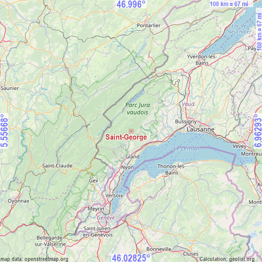
| Upper-left | 46.996°, | 5.55668° |
| Center: | 46.51428°, | 6.2598° |
| Lower-right: | 46.02825°, | 6.96293° |
| Map W x H: | 107.6×107.6 km | = 66.9×66.9mi |
| max Lat: | 47.76737° ⇑85.1% North |
| Saint-George: | 46.51428° |
| min Lat: | ⇓14.9% South 45.83203° |
| min Long | Saint-George | max Long |
| 5.97153° | 6.2598° | 10.44624° |
| W 2.6%⇐ | ⇒97.4% E |
Elevation
Elevation of Saint-George is 940 m = 3084 ft, and this is 381.8 m = 1253 ft above average elevation for this country.
| Max E: |
1845 m = 6053 ft | 6.5% |
| Saint-George | 940 m 3084 ft | |
| Avg. | 558.2 m = 1831 ft | |
Min E: |
197 m = 646 ft | 93.5% |
See also: Switzerland elevation on elevation.city.
Geographical zone
Saint-George is located in North temperate zone (between Tropic of Cancer and the Arctic Circle). Distance of this North polar circle is 2229.3 km =1385.2 mi to North.| Distance of | km | miles | from Saint-George |
|---|---|---|---|
| North Pole | 4835.2 | 3004.5 | to North |
| Arctic Circle | 2229.3 | 1385.2 | to North |
| Tropic Cancer | 2566 | 1594.4 | to South |
| Equator | 5171.9 | 3213.7 | to South |


Nearby cities:
15 places around Saint-George: (largest is in red/bold)
• Arzier
7.3 km =4.5 mi,  213°
213°
• Aubonne
10.3 km =6.4 mi,  101°
101°
• Ballens
9.8 km =6.1 mi,  62°
62°
• Begnins
8.1 km =5 mi,  186°
186°
• Berolle
7.6 km =4.7 mi,  50°
50°
• Bière
6.2 km =3.9 mi,  65°
65°
• Bursins
7.3 km =4.5 mi,  160°
160°
• Genolier
9.3 km =5.8 mi,  200°
200°
• Gilly
6.9 km =4.3 mi, 155°
• Gimel
3.7 km =2.3 mi, 98°
• Le Vaud
4.5 km =2.8 mi, 204°
• Perroy
8.9 km =5.5 mi,  126°
126°
• Rolle
8.5 km =5.3 mi,  137°
137°
• Saint-Livres
9.8 km =6.1 mi,  94°
94°
• Saubraz
5.4 km =3.4 mi, 87°
Sources, notices
• [Note1] Compared only with cities in Switzerland existing in our database
• [Src1] Map data: © OpenStreetMap contributors (CC-BY-SA)
• [Src2] Other city data from geonames.org with taken over terms of usage.
• [Src3] Geographical zone / Annual Mean Temperature by Robert A. Rohde @ Wikipedia
