Zhan’erxiang geodata
Zhan’erxiang (Gansu) is a seat of a fourth-order administrative division; located in China in Asia/Shanghai (GMT+8) time zone. In our database, there are 1268 cities with bigger population. Compared to other cities in China, 69.1% of cities are located further ↓South; 85.8% of cities are located further →East and 85.6% of cities have lower elevation than Zhan’erxiang. Note1


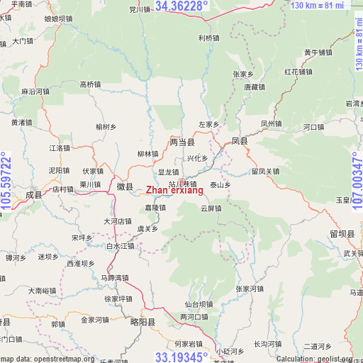
Zhan’erxiang GPS coordinates[2]
33° 46' 47.496" North, 106° 18' 1.224" East
| Map corner | latitude | longitude |
|---|---|---|
| Upper-left | 34.36228°, | 105.59722° |
| Center: | 33.77986°, | 106.30034° |
| Lower-right: | 33.19345°, | 107.00347° |
| Map W x H: | 130×130 km | = 80.8×80.8mi |
| max Lat: | 53.31946° ⇑30.9% North |
| Zhan’erxiang: | 33.77986° |
| min Lat: | ⇓69.1% South 18.22056° |
| min Long | Zhan’erxiang | max Long |
| 75.07348° | 106.30034° | 134.28917° |
| W 14.2%⇐ | ⇒85.8% E |
Elevation
Elevation of Zhan’erxiang is 1021 m = 3350 ft, and this is 536.2 m = 1759 ft above average elevation for this country.
| Max E: |
5622 m = 18445 ft | 14.4% |
| Zhan’erxiang | 1021 m 3350 ft | |
| Avg. | 484.8 m = 1591 ft | |
Min E: |
-3 m = -10 ft | 85.6% |
See also: China elevation on elevation.city.
Geographical zone
Zhan’erxiang is located in North temperate zone (between Tropic of Cancer and the Arctic Circle). Distance of this Northern Tropic circle is 1150 km =714.6 mi to South.| Distance of | km | miles | from Zhan’erxiang |
|---|---|---|---|
| North Pole | 6251.1 | 3884.3 | to North |
| Arctic Circle | 3645.2 | 2265 | to North |
| Tropic Cancer | 1150 | 714.6 | to South |
| Equator | 3756 | 2333.9 | to South |


Nearby cities:
15 places around Zhan’erxiang: (largest is in red/bold)
• Dongguan
17.9 km =11.1 mi,  270°
270°
• Huixian Chengguanzhen
20.3 km =12.6 mi, 266°
• Jialing
13.1 km =8.1 mi,  227°
227°
• Jindong
14.1 km =8.8 mi,  3°
3°
• Liangdang Chengguanzhen
14.4 km =8.9 mi, 0°
• Liulin
16 km =9.9 mi,  311°
311°
• Shuiyang
18.6 km =11.6 mi,  259°
259°
• Taishan
14.6 km =9.1 mi,  93°
93°
• Xianlong
6.4 km =4 mi, 306°
• Xinghua
10.7 km =6.6 mi,  32°
32°
• Xipo
14.2 km =8.8 mi,  57°
57°
• Yongning
12.3 km =7.6 mi,  302°
302°
• Yuchi
6.6 km =4.1 mi,  336°
336°
• Yuguan
20.2 km =12.6 mi,  217°
217°
• Yunping
13.9 km =8.6 mi,  130°
130°
Sources, notices
• [Note1] Compared only with cities in China existing in our database
• [Src1] Map data: © OpenStreetMap contributors (CC-BY-SA)
• [Src2] Other city data from geonames.org with taken over terms of usage.
• [Src3] Geographical zone / Annual Mean Temperature by Robert A. Rohde @ Wikipedia
