Yufa geodata
Yufa (Beijing) is a seat of a fourth-order administrative division; located in China in Asia/Shanghai (GMT+8) time zone. In our database, there are 1268 cities with bigger population. Compared to other cities in China, 84.7% of cities are located further ↓South; 61.9% of cities are located further ←West and 76.2% of cities have higher elevation than Yufa. Note1


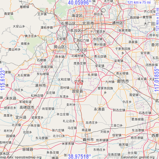
Yufa GPS coordinates[2]
39° 31' 10.884" North, 116° 18' 55.512" East
| Map corner | latitude | longitude |
|---|---|---|
| Upper-left | 40.05996°, | 115.6123° |
| Center: | 39.51969°, | 116.31542° |
| Lower-right: | 38.97518°, | 117.01855° |
| Map W x H: | 120.6×120.6 km | = 74.9×74.9mi |
| max Lat: | 53.31946° ⇑15.3% North |
| Yufa: | 39.51969° |
| min Lat: | ⇓84.7% South 18.22056° |
| min Long | Yufa | max Long |
| 75.07348° | 116.31542° | 134.28917° |
| W 61.9%⇐ | ⇒38.1% E |
Elevation
Elevation of Yufa is 34 m = 112 ft, and this is 450.8 m = 1479 ft below average elevation for this country.
| Max E: |
5622 m = 18445 ft | 76.2% |
| Avg. | 484.8 m = 1591 ft | |
| Yufa | 34 m = 112 ft | |
Min E: |
-3 m = -10 ft | 23.8% |
See also: China elevation on elevation.city.
Geographical zone
Yufa is located in North temperate zone (between Tropic of Cancer and the Arctic Circle). Distance of this Northern Tropic circle is 1788.3 km =1111.2 mi to South.| Distance of | km | miles | from Yufa |
|---|---|---|---|
| North Pole | 5612.9 | 3487.7 | to North |
| Arctic Circle | 3007 | 1868.5 | to North |
| Tropic Cancer | 1788.3 | 1111.2 | to South |
| Equator | 4394.2 | 2730.4 | to South |


Nearby cities:
15 places around Yufa: (largest is in red/bold)
• Anding
18.5 km =11.5 mi,  53°
53°
• Beizang
17.4 km =10.8 mi,  351°
351°
• Caiyu
29.7 km =18.5 mi,  60°
60°
• Daxing
24.5 km =15.2 mi,  2°
2°
• Gongchen
27.7 km =17.2 mi,  326°
326°
• Liangxiang
28.7 km =17.8 mi, 326°
• Liulihe
25.8 km =16 mi,  289°
289°
• Lixian
12 km =7.5 mi,  70°
70°
• Nanyuan
32.2 km =20 mi,  11°
11°
• Qingyundian
24 km =14.9 mi,  43°
43°
• Weishanzhuang
15 km =9.3 mi, 35°
• Xihongmen
30.2 km =18.8 mi, 4°
• Xingfeng
23.4 km =14.5 mi, 4°
• Yinghai
28.5 km =17.7 mi,  20°
20°
• Zhangziying
29.9 km =18.6 mi, 52°
Sources, notices
• [Note1] Compared only with cities in China existing in our database
• [Src1] Map data: © OpenStreetMap contributors (CC-BY-SA)
• [Src2] Other city data from geonames.org with taken over terms of usage.
• [Src3] Geographical zone / Annual Mean Temperature by Robert A. Rohde @ Wikipedia
