Xueyan geodata
Xueyan (Jiangsu) is a seat of a fourth-order administrative division; located in China in Asia/Shanghai (GMT+8) time zone. In our database, there are 1268 cities with bigger population. Compared to other cities in China, 58.5% of cities are located further ↓South; 82.5% of cities are located further ←West and 98.3% of cities have higher elevation than Xueyan. Note1


Xueyan GPS coordinates[2]
31° 30' 36.216" North, 120° 5' 40.956" East
| Map corner | latitude | longitude |
|---|---|---|
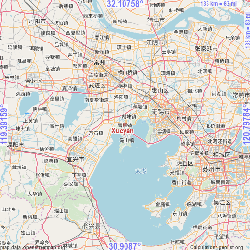
| Upper-left | 32.10758°, | 119.39159° |
| Center: | 31.51006°, | 120.09471° |
| Lower-right: | 30.9087°, | 120.79784° |
| Map W x H: | 133.3×133.3 km | = 82.8×82.8mi |
| max Lat: | 53.31946° ⇑41.5% North |
| Xueyan: | 31.51006° |
| min Lat: | ⇓58.5% South 18.22056° |
| min Long | Xueyan | max Long |
| 75.07348° | 120.09471° | 134.28917° |
| W 82.5%⇐ | ⇒17.5% E |
Elevation
Elevation of Xueyan is 4 m = 13 ft, and this is 480.8 m = 1577 ft below average elevation for this country.
| Max E: |
5622 m = 18445 ft | 98.3% |
| Avg. | 484.8 m = 1591 ft | |
| Xueyan | 4 m = 13 ft | |
Min E: |
-3 m = -10 ft | 1.7% |
See also: China elevation on elevation.city.
Geographical zone
Xueyan is located in North temperate zone (between Tropic of Cancer and the Arctic Circle). Distance of this Northern Tropic circle is 897.7 km =557.8 mi to South.| Distance of | km | miles | from Xueyan |
|---|---|---|---|
| North Pole | 6503.5 | 4041.1 | to North |
| Arctic Circle | 3897.6 | 2421.9 | to North |
| Tropic Cancer | 897.7 | 557.8 | to South |
| Equator | 3503.6 | 2177 | to South |


Nearby cities:
15 places around Xueyan: (largest is in red/bold)
• Hudai
4.9 km =3 mi,  28°
28°
• Lihu
16 km =9.9 mi,  83°
83°
• Lijia
15.5 km =9.6 mi,  329°
329°
• Liyuan
16.3 km =10.1 mi, 76°
• Luoshe
17.1 km =10.6 mi, 29°
• Luoyang
15.3 km =9.5 mi,  353°
353°
• Maji
7.9 km =4.9 mi,  174°
174°
• Mashan
5 km =3.1 mi,  146°
146°
• Qianhuang
15.9 km =9.9 mi,  307°
307°
• Qianqiao
16 km =9.9 mi,  50°
50°
• Rongxiang
13.9 km =8.6 mi,  67°
67°
• Wanshi
16.3 km =10.1 mi,  256°
256°
• Yangshan
7.7 km =4.8 mi, 354°
• Yugang
10 km =6.2 mi, 67°
• Zhoutie
12.3 km =7.6 mi,  229°
229°
Sources, notices
• [Note1] Compared only with cities in China existing in our database
• [Src1] Map data: © OpenStreetMap contributors (CC-BY-SA)
• [Src2] Other city data from geonames.org with taken over terms of usage.
• [Src3] Geographical zone / Annual Mean Temperature by Robert A. Rohde @ Wikipedia
