Wentang geodata
Wentang (Hunan) is a seat of a fourth-order administrative division; located in China in Asia/Shanghai (GMT+8) time zone. In our database, there are 1268 cities with bigger population. Compared to other cities in China, 63.5% of cities are located further ↑North; 70.4% of cities are located further →East and 59.9% of cities have lower elevation than Wentang. Note1


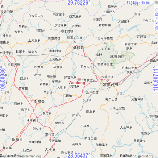
Wentang GPS coordinates[2]
29° 10' 12.54" North, 110° 12' 14.328" East
| Map corner | latitude | longitude |
|---|---|---|
| Upper-left | 29.78226°, | 109.50086° |
| Center: | 29.17015°, | 110.20398° |
| Lower-right: | 28.55437°, | 110.90711° |
| Map W x H: | 136.5×136.5 km | = 84.8×84.8mi |
| max Lat: | 53.31946° ⇑63.5% North |
| Wentang: | 29.17015° |
| min Lat: | ⇓36.5% South 18.22056° |
| min Long | Wentang | max Long |
| 75.07348° | 110.20398° | 134.28917° |
| W 29.6%⇐ | ⇒70.4% E |
Elevation
Elevation of Wentang is 258 m = 846 ft, and this is 226.8 m = 744 ft below average elevation for this country.
| Max E: |
5622 m = 18445 ft | 40.1% |
| Avg. | 484.8 m = 1591 ft | |
| Wentang | 258 m = 846 ft | |
Min E: |
-3 m = -10 ft | 59.9% |
See also: China elevation on elevation.city.
Geographical zone
Wentang is located in North temperate zone (between Tropic of Cancer and the Arctic Circle). Distance of this Northern Tropic circle is 637.5 km =396.1 mi to South.| Distance of | km | miles | from Wentang |
|---|---|---|---|
| North Pole | 6763.6 | 4202.7 | to North |
| Arctic Circle | 4157.8 | 2583.5 | to North |
| Tropic Cancer | 637.5 | 396.1 | to South |
| Equator | 3243.4 | 2015.4 | to South |


Nearby cities:
15 places around Wentang: (largest is in red/bold)
• Cheping
19.6 km =12.2 mi,  264°
264°
• Chexi
7.1 km =4.4 mi,  210°
210°
• Daming
16.4 km =10.2 mi,  244°
244°
• Fengxianggang
19.6 km =12.2 mi,  109°
109°
• Houping
16.2 km =10.1 mi,  135°
135°
• Jiaoziya
17.5 km =10.9 mi,  41°
41°
• Luoshui
11.9 km =7.4 mi,  23°
23°
• Luotaping
7.9 km =4.9 mi,  283°
283°
• Qingping
16 km =9.9 mi,  171°
171°
• Qing’anping
13.2 km =8.2 mi,  338°
338°
• Sanjiaguan
8.4 km =5.2 mi,  95°
95°
• Shidixi
17.2 km =10.7 mi, 214°
• Xiangjiazhai
19.7 km =12.2 mi, 281°
• Yinjiaxi
20.3 km =12.6 mi, 100°
• Yongmao
18.6 km =11.6 mi,  158°
158°
Sources, notices
• [Note1] Compared only with cities in China existing in our database
• [Src1] Map data: © OpenStreetMap contributors (CC-BY-SA)
• [Src2] Other city data from geonames.org with taken over terms of usage.
• [Src3] Geographical zone / Annual Mean Temperature by Robert A. Rohde @ Wikipedia
