Wenquan geodata
Wenquan (Jiangxi) is a seat of a fourth-order administrative division; located in China in Asia/Shanghai (GMT+8) time zone. In our database, there are 1268 cities with bigger population. Compared to other cities in China, 60.6% of cities are located further ↑North; 59.4% of cities are located further ←West and 65.8% of cities have higher elevation than Wenquan. Note1


Wenquan GPS coordinates[2]
29° 24' 57.312" North, 115° 53' 23.172" East
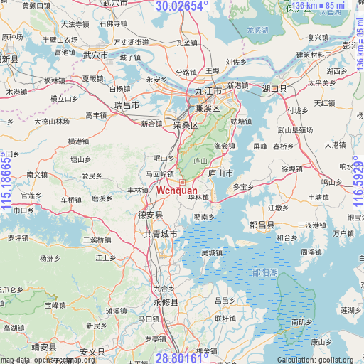
| Map corner | latitude | longitude |
|---|---|---|
| Upper-left | 30.02654°, | 115.18665° |
| Center: | 29.41592°, | 115.88977° |
| Lower-right: | 28.80161°, | 116.5929° |
| Map W x H: | 136.2×136.2 km | = 84.6×84.6mi |
| max Lat: | 53.31946° ⇑60.6% North |
| Wenquan: | 29.41592° |
| min Lat: | ⇓39.4% South 18.22056° |
| min Long | Wenquan | max Long |
| 75.07348° | 115.88977° | 134.28917° |
| W 59.4%⇐ | ⇒40.6% E |
Elevation
Elevation of Wenquan is 69 m = 226 ft, and this is 415.8 m = 1364 ft below average elevation for this country.
| Max E: |
5622 m = 18445 ft | 65.8% |
| Avg. | 484.8 m = 1591 ft | |
| Wenquan | 69 m = 226 ft | |
Min E: |
-3 m = -10 ft | 34.2% |
See also: China elevation on elevation.city.
Geographical zone
Wenquan is located in North temperate zone (between Tropic of Cancer and the Arctic Circle). Distance of this Northern Tropic circle is 664.8 km =413.1 mi to South.| Distance of | km | miles | from Wenquan |
|---|---|---|---|
| North Pole | 6736.3 | 4185.7 | to North |
| Arctic Circle | 4130.4 | 2566.5 | to North |
| Tropic Cancer | 664.8 | 413.1 | to South |
| Equator | 3270.7 | 2032.3 | to South |


Nearby cities:
15 places around Wenquan: (largest is in red/bold)
• Bailu
16.5 km =10.3 mi,  61°
61°
• Gaotang
11.1 km =6.9 mi,  269°
269°
• Hedong
14.8 km =9.2 mi,  234°
234°
• Hengtang
7.7 km =4.8 mi,  182°
182°
• Hualin
7.9 km =4.9 mi,  131°
131°
• Jiaotang
12.2 km =7.6 mi,  164°
164°
• Jinhu
15.8 km =9.8 mi,  207°
207°
• Liaohua
10.6 km =6.6 mi,  103°
103°
• Liaonan
14.9 km =9.3 mi,  149°
149°
• Linquan
16.5 km =10.3 mi,  287°
287°
• Mahuiling
9.2 km =5.7 mi, 291°
• Nankang
15 km =9.3 mi,  76°
76°
• Puting
15.9 km =9.9 mi, 233°
• Sujiadang
15.6 km =9.7 mi,  186°
186°
• Zequan
11 km =6.8 mi,  202°
202°
Sources, notices
• [Note1] Compared only with cities in China existing in our database
• [Src1] Map data: © OpenStreetMap contributors (CC-BY-SA)
• [Src2] Other city data from geonames.org with taken over terms of usage.
• [Src3] Geographical zone / Annual Mean Temperature by Robert A. Rohde @ Wikipedia
