Wangdingdi geodata
Wangdingdi (Tianjin) is a seat of a fourth-order administrative division; located in China in Asia/Shanghai (GMT+8) time zone. In our database, there are 1268 cities with bigger population. Compared to other cities in China, 83.2% of cities are located further ↓South; 66.6% of cities are located further ←West and 95.9% of cities have higher elevation than Wangdingdi. Note1


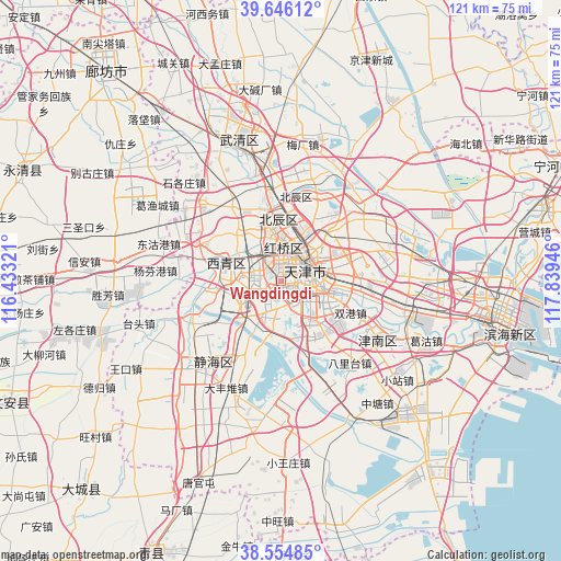
Wangdingdi GPS coordinates[2]
39° 6' 9.36" North, 117° 8' 10.788" East
| Map corner | latitude | longitude |
|---|---|---|
| Upper-left | 39.64612°, | 116.43321° |
| Center: | 39.1026°, | 117.13633° |
| Lower-right: | 38.55485°, | 117.83946° |
| Map W x H: | 121.3×121.3 km | = 75.4×75.4mi |
| max Lat: | 53.31946° ⇑16.8% North |
| Wangdingdi: | 39.1026° |
| min Lat: | ⇓83.2% South 18.22056° |
| min Long | Wangdingdi | max Long |
| 75.07348° | 117.13633° | 134.28917° |
| W 66.6%⇐ | ⇒33.4% E |
Elevation
Elevation of Wangdingdi is 6 m = 20 ft, and this is 478.8 m = 1571 ft below average elevation for this country.
| Max E: |
5622 m = 18445 ft | 95.9% |
| Avg. | 484.8 m = 1591 ft | |
| Wangdingdi | 6 m = 20 ft | |
Min E: |
-3 m = -10 ft | 4.1% |
See also: China elevation on elevation.city.
Geographical zone
Wangdingdi is located in North temperate zone (between Tropic of Cancer and the Arctic Circle). Distance of this Northern Tropic circle is 1741.9 km =1082.4 mi to South.| Distance of | km | miles | from Wangdingdi |
|---|---|---|---|
| North Pole | 5659.3 | 3516.5 | to North |
| Arctic Circle | 3053.4 | 1897.3 | to North |
| Tropic Cancer | 1741.9 | 1082.4 | to South |
| Equator | 4347.8 | 2701.6 | to South |


Nearby cities:
15 places around Wangdingdi: (largest is in red/bold)
• Balitai
2.7 km =1.7 mi,  105°
105°
• Changhongjie
4 km =2.5 mi,  14°
14°
• Guangkai
4.2 km =2.6 mi,  31°
31°
• Lingdangge
4.6 km =2.9 mi, 5°
• Liqizhuang
4.3 km =2.7 mi,  148°
148°
• Nanshi
4.7 km =2.9 mi,  55°
55°
• Nanyingmen
4 km =2.5 mi,  66°
66°
• Tianta
4.5 km =2.8 mi,  121°
121°
• Tiyu Zhongxin
4.8 km =3 mi,  144°
144°
• Tiyuguan
4.9 km =3 mi,  81°
81°
• Wanxing
2.8 km =1.7 mi,  40°
40°
• Xiangyanglu
3.7 km =2.3 mi,  345°
345°
• Xingnan
3.9 km =2.4 mi,  49°
49°
• Xinxing
3.8 km =2.4 mi,  87°
87°
• Xuefu
2.3 km =1.4 mi, 62°
Sources, notices
• [Note1] Compared only with cities in China existing in our database
• [Src1] Map data: © OpenStreetMap contributors (CC-BY-SA)
• [Src2] Other city data from geonames.org with taken over terms of usage.
• [Src3] Geographical zone / Annual Mean Temperature by Robert A. Rohde @ Wikipedia
