Tangxia geodata
Tangxia (Guangdong) is a seat of a fourth-order administrative division; located in China in Asia/Shanghai (GMT+8) time zone. In our database, there are 1268 cities with bigger population. Compared to other cities in China, 95.3% of cities are located further ↑North; 50.8% of cities are located further →East and 79.8% of cities have higher elevation than Tangxia. Note1


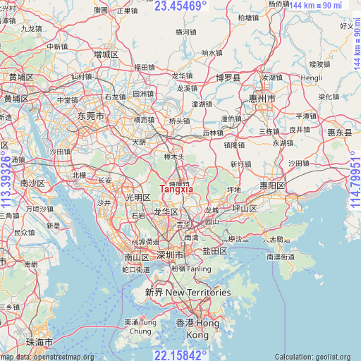
Tangxia GPS coordinates[2]
22° 48' 29.16" North, 114° 5' 46.968" East
| Map corner | latitude | longitude |
|---|---|---|
| Upper-left | 23.45469°, | 113.39326° |
| Center: | 22.8081°, | 114.09638° |
| Lower-right: | 22.15842°, | 114.79951° |
| Map W x H: | 144.1×144.1 km | = 89.5×89.5mi |
| max Lat: | 53.31946° ⇑95.3% North |
| Tangxia: | 22.8081° |
| min Lat: | ⇓4.7% South 18.22056° |
| min Long | Tangxia | max Long |
| 75.07348° | 114.09638° | 134.28917° |
| W 49.2%⇐ | ⇒50.8% E |
Elevation
Elevation of Tangxia is 27 m = 89 ft, and this is 457.8 m = 1502 ft below average elevation for this country.
| Max E: |
5622 m = 18445 ft | 79.8% |
| Avg. | 484.8 m = 1591 ft | |
| Tangxia | 27 m = 89 ft | |
Min E: |
-3 m = -10 ft | 20.2% |
See also: China elevation on elevation.city.
Geographical zone
Tangxia is located in North Torrid zone (between Equator and Tropic of Cancer). Distance of this Northern Tropic circle is 69.9 km =43.4 mi to North.| Distance of | km | miles | from Tangxia |
|---|---|---|---|
| North Pole | 7471 | 4642.3 | to North |
| Arctic Circle | 4865.2 | 3023.1 | to North |
| Tropic Cancer | 69.9 | 43.4 | to North |
| Equator | 2536 | 1575.8 | to South |


Nearby cities:
15 places around Tangxia: (largest is in red/bold)
• Bantian
19.7 km =12.2 mi,  194°
194°
• Dalang
17.1 km =10.6 mi,  211°
211°
• Fenggang
7.8 km =4.8 mi,  136°
136°
• Guangming
17.5 km =10.9 mi,  256°
256°
• Guanlan
10.7 km =6.6 mi,  204°
204°
• Henggang
20.4 km =12.7 mi,  149°
149°
• Huangjiang
16.2 km =10.1 mi,  320°
320°
• Longcheng
16.9 km =10.5 mi,  133°
133°
• Longgang
19.6 km =12.2 mi,  118°
118°
• Longhua
19 km =11.8 mi, 208°
• Pinghu
13.2 km =8.2 mi,  170°
170°
• Qingxi
7.7 km =4.8 mi,  65°
65°
• Shiyan
20.9 km =13 mi,  229°
229°
• Xiegang
17.6 km =10.9 mi,  15°
15°
• Zhangmutou
9.6 km =6 mi,  344°
344°
Sources, notices
• [Note1] Compared only with cities in China existing in our database
• [Src1] Map data: © OpenStreetMap contributors (CC-BY-SA)
• [Src2] Other city data from geonames.org with taken over terms of usage.
• [Src3] Geographical zone / Annual Mean Temperature by Robert A. Rohde @ Wikipedia
