Magutian geodata
Magutian (Henan) is a seat of a fourth-order administrative division; located in China in Asia/Shanghai (GMT+8) time zone. In our database, there are 1268 cities with bigger population. Compared to other cities in China, 64.7% of cities are located further ↓South; 54.5% of cities are located further →East and 51% of cities have lower elevation than Magutian. Note1


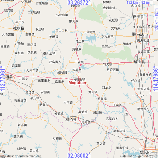
Magutian GPS coordinates[2]
32° 40' 25.788" North, 113° 28' 25.428" East
| Map corner | latitude | longitude |
|---|---|---|
| Upper-left | 33.26372°, | 112.77061° |
| Center: | 32.67383°, | 113.47373° |
| Lower-right: | 32.08002°, | 114.17686° |
| Map W x H: | 131.6×131.6 km | = 81.8×81.8mi |
| max Lat: | 53.31946° ⇑35.3% North |
| Magutian: | 32.67383° |
| min Lat: | ⇓64.7% South 18.22056° |
| min Long | Magutian | max Long |
| 75.07348° | 113.47373° | 134.28917° |
| W 45.5%⇐ | ⇒54.5% E |
Elevation
Elevation of Magutian is 173 m = 568 ft, and this is 311.8 m = 1023 ft below average elevation for this country.
| Max E: |
5622 m = 18445 ft | 49% |
| Avg. | 484.8 m = 1591 ft | |
| Magutian | 173 m = 568 ft | |
Min E: |
-3 m = -10 ft | 51% |
See also: China elevation on elevation.city.
Geographical zone
Magutian is located in North temperate zone (between Tropic of Cancer and the Arctic Circle). Distance of this Northern Tropic circle is 1027.1 km =638.2 mi to South.| Distance of | km | miles | from Magutian |
|---|---|---|---|
| North Pole | 6374.1 | 3960.7 | to North |
| Arctic Circle | 3768.2 | 2341.5 | to North |
| Tropic Cancer | 1027.1 | 638.2 | to South |
| Equator | 3633 | 2257.4 | to South |


Nearby cities:
15 places around Magutian: (largest is in red/bold)
• Bishui
15.9 km =9.9 mi,  287°
287°
• Chenzhuang
16.6 km =10.3 mi,  263°
263°
• Fuzhuang
31.7 km =19.7 mi,  0°
0°
• Gaodian
22.6 km =14 mi, 260°
• Gaoyi
7.9 km =4.9 mi,  348°
348°
• Guanzhuang
28.9 km =18 mi,  324°
324°
• Huayuan
15.4 km =9.6 mi, 290°
• Jialou
24.7 km =15.3 mi, 354°
• Shewan
22.8 km =14.2 mi, 287°
• Shuangmiaojie
24.8 km =15.4 mi,  305°
305°
• Taishanmiao
33 km =20.5 mi, 311°
• Tongbai Chengguanzhen
35.2 km =21.9 mi,  191°
191°
• Tongshan
13.5 km =8.4 mi,  35°
35°
• Wangdian
14.4 km =8.9 mi,  359°
359°
• Yangjiaji
21.4 km =13.3 mi, 323°
Sources, notices
• [Note1] Compared only with cities in China existing in our database
• [Src1] Map data: © OpenStreetMap contributors (CC-BY-SA)
• [Src2] Other city data from geonames.org with taken over terms of usage.
• [Src3] Geographical zone / Annual Mean Temperature by Robert A. Rohde @ Wikipedia
