Lingchuan geodata
Lingchuan (Fujian) is a seat of a fourth-order administrative division; located in China in Asia/Shanghai (GMT+8) time zone. In our database, there are 1268 cities with bigger population. Compared to other cities in China, 85.1% of cities are located further ↑North; 75.8% of cities are located further ←West and 82.1% of cities have higher elevation than Lingchuan. Note1


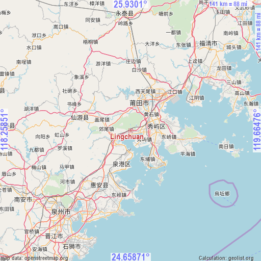
Lingchuan GPS coordinates[2]
25° 17' 45.852" North, 118° 57' 41.868" East
| Map corner | latitude | longitude |
|---|---|---|
| Upper-left | 25.9301°, | 118.25851° |
| Center: | 25.29607°, | 118.96163° |
| Lower-right: | 24.65871°, | 119.66476° |
| Map W x H: | 141.4×141.4 km | = 87.9×87.9mi |
| max Lat: | 53.31946° ⇑85.1% North |
| Lingchuan: | 25.29607° |
| min Lat: | ⇓14.9% South 18.22056° |
| min Long | Lingchuan | max Long |
| 75.07348° | 118.96163° | 134.28917° |
| W 75.8%⇐ | ⇒24.2% E |
Elevation
Elevation of Lingchuan is 22 m = 72 ft, and this is 462.8 m = 1518 ft below average elevation for this country.
| Max E: |
5622 m = 18445 ft | 82.1% |
| Avg. | 484.8 m = 1591 ft | |
| Lingchuan | 22 m = 72 ft | |
Min E: |
-3 m = -10 ft | 17.9% |
See also: China elevation on elevation.city.
Geographical zone
Lingchuan is located in North temperate zone (between Tropic of Cancer and the Arctic Circle). Distance of this Northern Tropic circle is 206.7 km =128.4 mi to South.| Distance of | km | miles | from Lingchuan |
|---|---|---|---|
| North Pole | 7194.4 | 4470.4 | to North |
| Arctic Circle | 4588.5 | 2851.2 | to North |
| Tropic Cancer | 206.7 | 128.4 | to South |
| Equator | 2812.7 | 1747.7 | to South |


Nearby cities:
15 places around Lingchuan: (largest is in red/bold)
• Chengnan
15.7 km =9.8 mi,  18°
18°
• Chengxiao
17.4 km =10.8 mi, 19°
• Donghai
5 km =3.1 mi,  242°
242°
• Fengting
12.6 km =7.8 mi, 243°
• Gaiwei
16.8 km =10.4 mi,  291°
291°
• Huangshi
14.4 km =8.9 mi,  50°
50°
• Huating
12.1 km =7.5 mi,  322°
322°
• Hushi
13 km =8.1 mi,  79°
79°
• Jiaowei
13.2 km =8.2 mi,  275°
275°
• Jieshan
13.6 km =8.5 mi,  232°
232°
• Putian
16.7 km =10.4 mi, 17°
• Xindu
13.8 km =8.6 mi,  33°
33°
• Xiuyu
8.6 km =5.3 mi,  121°
121°
• Yuetang
14.6 km =9.1 mi, 115°
• Zhongmen
16.6 km =10.3 mi,  133°
133°
Sources, notices
• [Note1] Compared only with cities in China existing in our database
• [Src1] Map data: © OpenStreetMap contributors (CC-BY-SA)
• [Src2] Other city data from geonames.org with taken over terms of usage.
• [Src3] Geographical zone / Annual Mean Temperature by Robert A. Rohde @ Wikipedia
