Jiebu geodata
Jiebu (Jiangxi) is a seat of a fourth-order administrative division; located in China in Asia/Shanghai (GMT+8) time zone. In our database, there are 1268 cities with bigger population. Compared to other cities in China, 75.3% of cities are located further ↑North; 56.3% of cities are located further ←West and 74.8% of cities have higher elevation than Jiebu. Note1


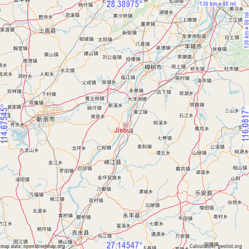
Jiebu GPS coordinates[2]
27° 46' 9.804" North, 115° 22' 42.852" East
| Map corner | latitude | longitude |
|---|---|---|
| Upper-left | 28.38975°, | 114.67545° |
| Center: | 27.76939°, | 115.37857° |
| Lower-right: | 27.14547°, | 116.0817° |
| Map W x H: | 138.4×138.4 km | = 86×86mi |
| max Lat: | 53.31946° ⇑75.3% North |
| Jiebu: | 27.76939° |
| min Lat: | ⇓24.7% South 18.22056° |
| min Long | Jiebu | max Long |
| 75.07348° | 115.37857° | 134.28917° |
| W 56.3%⇐ | ⇒43.7% E |
Elevation
Elevation of Jiebu is 37 m = 121 ft, and this is 447.8 m = 1469 ft below average elevation for this country.
| Max E: |
5622 m = 18445 ft | 74.8% |
| Avg. | 484.8 m = 1591 ft | |
| Jiebu | 37 m = 121 ft | |
Min E: |
-3 m = -10 ft | 25.2% |
See also: China elevation on elevation.city.
Geographical zone
Jiebu is located in North temperate zone (between Tropic of Cancer and the Arctic Circle). Distance of this Northern Tropic circle is 481.7 km =299.3 mi to South.| Distance of | km | miles | from Jiebu |
|---|---|---|---|
| North Pole | 6919.4 | 4299.5 | to North |
| Arctic Circle | 4313.5 | 2680.3 | to North |
| Tropic Cancer | 481.7 | 299.3 | to South |
| Equator | 3087.7 | 1918.6 | to South |


Nearby cities:
15 places around Jiebu: (largest is in red/bold)
• Changfu
18.2 km =11.3 mi,  337°
337°
• Dayangzhou
16.1 km =10 mi,  25°
25°
• Hebu
7.5 km =4.7 mi,  8°
8°
• Jinchuan
1.4 km =0.9 mi,  135°
135°
• Lijiang
11.5 km =7.1 mi,  48°
48°
• Nan’an
15.5 km =9.6 mi,  288°
288°
• Renhe
17.1 km =10.6 mi,  222°
222°
• Sanhu
17.9 km =11.1 mi,  15°
15°
• Shenzhengqiao
10.6 km =6.6 mi,  128°
128°
• Shuibian
18.7 km =11.6 mi,  195°
195°
• Taoxi
20 km =12.4 mi,  85°
85°
• Xinxi
12.2 km =7.6 mi, 335°
• Yaoxu
19.2 km =11.9 mi,  299°
299°
• Yijiang
7.9 km =4.9 mi, 197°
• Yongtai
20.3 km =12.6 mi, 17°
Sources, notices
• [Note1] Compared only with cities in China existing in our database
• [Src1] Map data: © OpenStreetMap contributors (CC-BY-SA)
• [Src2] Other city data from geonames.org with taken over terms of usage.
• [Src3] Geographical zone / Annual Mean Temperature by Robert A. Rohde @ Wikipedia
