Huzhou geodata
Huzhou (Zhejiang) is a seat of a second-order administrative division; located in China in Asia/Shanghai (GMT+8) time zone. With population of 158,320 people, there are 276 cities with bigger population in this country. Compared to other cities in China, 53.6% of cities are located further ↓South; 82.5% of cities are located further ←West and 95.9% of cities have higher elevation than Huzhou. Note1


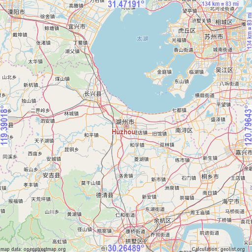
Huzhou GPS coordinates[2]
30° 52' 13.08" North, 120° 5' 35.88" East
| Map corner | latitude | longitude |
|---|---|---|
| Upper-left | 31.47191°, | 119.39018° |
| Center: | 30.8703°, | 120.0933° |
| Lower-right: | 30.26489°, | 120.79643° |
| Map W x H: | 134.2×134.2 km | = 83.4×83.4mi |
| max Lat: | 53.31946° ⇑46.4% North |
| Huzhou: | 30.8703° |
| min Lat: | ⇓53.6% South 18.22056° |
| min Long | Huzhou | max Long |
| 75.07348° | 120.0933° | 134.28917° |
| W 82.5%⇐ | ⇒17.5% E |
Elevation
Elevation of Huzhou is 6 m = 20 ft, and this is 478.8 m = 1571 ft below average elevation for this country.
| Max E: |
5622 m = 18445 ft | 95.9% |
| Avg. | 484.8 m = 1591 ft | |
| Huzhou | 6 m = 20 ft | |
Min E: |
-3 m = -10 ft | 4.1% |
See also: Huzhou elevation on elevation.city.
Geographical zone
Huzhou is located in North temperate zone (between Tropic of Cancer and the Arctic Circle). Distance of this Northern Tropic circle is 826.5 km =513.6 mi to South.| Distance of | km | miles | from Huzhou |
|---|---|---|---|
| North Pole | 6574.6 | 4085.3 | to North |
| Arctic Circle | 3968.7 | 2466 | to North |
| Tropic Cancer | 826.5 | 513.6 | to South |
| Equator | 3432.5 | 2132.9 | to South |


Nearby cities:
15 places around Huzhou: (largest is in red/bold)
• Baique
5.6 km =3.5 mi,  4°
4°
• Balidian
6.5 km =4 mi,  118°
118°
• Daochang
2.4 km =1.5 mi,  181°
181°
• Hefu
11.8 km =7.3 mi,  148°
148°
• Hongqiao
16.8 km =10.4 mi,  321°
321°
• Jiuguan
17.9 km =11.1 mi,  101°
101°
• Lijiaxiang
14.3 km =8.9 mi,  308°
308°
• Linghu
18.6 km =11.6 mi,  155°
155°
• Longquan
1 km =0.6 mi, 96°
• Lüshan
18 km =11.2 mi,  291°
291°
• Miaoxi
13 km =8.1 mi,  220°
220°
• Nangaoqiao
5.6 km =3.5 mi, 4°
• Sujiazhuang
2.2 km =1.4 mi,  278°
278°
• Tianshengjie
2 km =1.2 mi,  65°
65°
• Zhili
15.6 km =9.7 mi,  88°
88°
Sources, notices
• [Note1] Compared only with cities in China existing in our database
• [Src1] Map data: © OpenStreetMap contributors (CC-BY-SA)
• [Src2] Other city data from geonames.org with taken over terms of usage.
• [Src3] Geographical zone / Annual Mean Temperature by Robert A. Rohde @ Wikipedia
