Hengxizhen geodata
Hengxizhen (Zhejiang) is a seat of a fourth-order administrative division; located in China in Asia/Shanghai (GMT+8) time zone. In our database, there are 1268 cities with bigger population. Compared to other cities in China, 57.1% of cities are located further ↑North; 90.3% of cities are located further ←West and 91.2% of cities have higher elevation than Hengxizhen. Note1


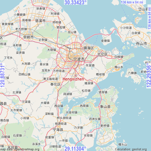
Hengxizhen GPS coordinates[2]
29° 43' 31.764" North, 121° 35' 25.548" East
| Map corner | latitude | longitude |
|---|---|---|
| Upper-left | 30.33423°, | 120.88731° |
| Center: | 29.72549°, | 121.59043° |
| Lower-right: | 29.11304°, | 122.29356° |
| Map W x H: | 135.8×135.8 km | = 84.4×84.4mi |
| max Lat: | 53.31946° ⇑57.1% North |
| Hengxizhen: | 29.72549° |
| min Lat: | ⇓42.9% South 18.22056° |
| min Long | Hengxizhen | max Long |
| 75.07348° | 121.59043° | 134.28917° |
| W 90.3%⇐ | ⇒9.7% E |
Elevation
Elevation of Hengxizhen is 9 m = 30 ft, and this is 475.8 m = 1561 ft below average elevation for this country.
| Max E: |
5622 m = 18445 ft | 91.2% |
| Avg. | 484.8 m = 1591 ft | |
| Hengxizhen | 9 m = 30 ft | |
Min E: |
-3 m = -10 ft | 8.8% |
See also: China elevation on elevation.city.
Geographical zone
Hengxizhen is located in North temperate zone (between Tropic of Cancer and the Arctic Circle). Distance of this Northern Tropic circle is 699.2 km =434.5 mi to South.| Distance of | km | miles | from Hengxizhen |
|---|---|---|---|
| North Pole | 6701.9 | 4164.4 | to North |
| Arctic Circle | 4096 | 2545.1 | to North |
| Tropic Cancer | 699.2 | 434.5 | to South |
| Equator | 3305.2 | 2053.8 | to South |


Nearby cities:
15 places around Hengxizhen: (largest is in red/bold)
• Dongqianhu
8.4 km =5.2 mi,  28°
28°
• Dongwu
15.8 km =9.8 mi,  53°
53°
• Duantang
15.3 km =9.5 mi,  335°
335°
• Jiangshan
7.6 km =4.7 mi,  311°
311°
• Maoshan
9.4 km =5.8 mi,  283°
283°
• Qiucun
13.8 km =8.6 mi,  167°
167°
• Qiu’ai
14.6 km =9.1 mi,  15°
15°
• Shiqi
13.6 km =8.5 mi,  322°
322°
• Song’ao
15.6 km =9.7 mi,  143°
143°
• Tangtou
13.4 km =8.3 mi,  117°
117°
• Wuxiang
16.3 km =10.1 mi, 34°
• Xiaying
8.8 km =5.5 mi,  0°
0°
• Xiwu
11.3 km =7 mi,  245°
245°
• Yunlong
5.4 km =3.4 mi, 1°
• Zhonggongmiao
12.3 km =7.6 mi, 335°
Sources, notices
• [Note1] Compared only with cities in China existing in our database
• [Src1] Map data: © OpenStreetMap contributors (CC-BY-SA)
• [Src2] Other city data from geonames.org with taken over terms of usage.
• [Src3] Geographical zone / Annual Mean Temperature by Robert A. Rohde @ Wikipedia
