Gongping geodata
Gongping (Guangdong) is a seat of a fourth-order administrative division; located in China in Asia/Shanghai (GMT+8) time zone. In our database, there are 1268 cities with bigger population. Compared to other cities in China, 94.1% of cities are located further ↑North; 56.4% of cities are located further ←West and 86.9% of cities have higher elevation than Gongping. Note1


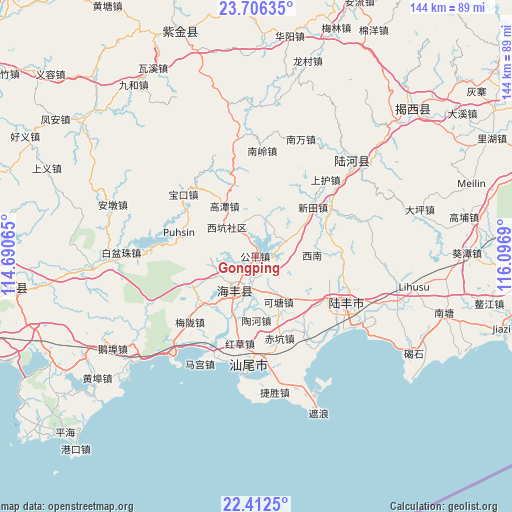
Gongping GPS coordinates[2]
23° 3' 39.528" North, 115° 23' 37.572" East
| Map corner | latitude | longitude |
|---|---|---|
| Upper-left | 23.70635°, | 114.69065° |
| Center: | 23.06098°, | 115.39377° |
| Lower-right: | 22.4125°, | 116.0969° |
| Map W x H: | 143.9×143.9 km | = 89.4×89.4mi |
| max Lat: | 53.31946° ⇑94.1% North |
| Gongping: | 23.06098° |
| min Lat: | ⇓5.9% South 18.22056° |
| min Long | Gongping | max Long |
| 75.07348° | 115.39377° | 134.28917° |
| W 56.4%⇐ | ⇒43.6% E |
Elevation
Elevation of Gongping is 13 m = 43 ft, and this is 471.8 m = 1548 ft below average elevation for this country.
| Max E: |
5622 m = 18445 ft | 86.9% |
| Avg. | 484.8 m = 1591 ft | |
| Gongping | 13 m = 43 ft | |
Min E: |
-3 m = -10 ft | 13.1% |
See also: China elevation on elevation.city.
Geographical zone
Gongping is located in North Torrid zone (between Equator and Tropic of Cancer). Distance of this Northern Tropic circle is 41.8 km =26 mi to North.| Distance of | km | miles | from Gongping |
|---|---|---|---|
| North Pole | 7442.9 | 4624.8 | to North |
| Arctic Circle | 4837 | 3005.6 | to North |
| Tropic Cancer | 41.8 | 26 | to North |
| Equator | 2564.1 | 1593.3 | to South |


Nearby cities:
15 places around Gongping: (largest is in red/bold)
• Chikeng
24 km =14.9 mi,  163°
163°
• Da’an
25 km =15.5 mi,  88°
88°
• Gaotan
16.4 km =10.2 mi,  326°
326°
• Haicheng
11.4 km =7.1 mi,  213°
213°
• Hekou
25.5 km =15.8 mi,  58°
58°
• Hexi
22.5 km =14 mi,  116°
116°
• Huangqiang
10.4 km =6.5 mi,  14°
14°
• Ketang
15.5 km =9.6 mi,  153°
153°
• Lian’an
19.3 km =12 mi, 211°
• Pingdong
10.5 km =6.5 mi,  66°
66°
• Tanxi
22.2 km =13.8 mi,  128°
128°
• Taohe
18.5 km =11.5 mi,  174°
174°
• Xinan
16.1 km =10 mi, 89°
• Xintian
21 km =13 mi,  49°
49°
• Xin’an
21.8 km =13.5 mi,  287°
287°
Sources, notices
• [Note1] Compared only with cities in China existing in our database
• [Src1] Map data: © OpenStreetMap contributors (CC-BY-SA)
• [Src2] Other city data from geonames.org with taken over terms of usage.
• [Src3] Geographical zone / Annual Mean Temperature by Robert A. Rohde @ Wikipedia
