Fuchuan geodata
Fuchuan (Shaanxi) is a seat of a fourth-order administrative division; located in China in Asia/Shanghai (GMT+8) time zone. In our database, there are 1268 cities with bigger population. Compared to other cities in China, 66.1% of cities are located further ↓South; 84.6% of cities are located further →East and 78.7% of cities have lower elevation than Fuchuan. Note1


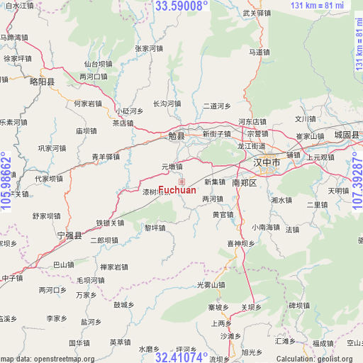
Fuchuan GPS coordinates[2]
33° 0' 8.568" North, 106° 41' 23.064" East
| Map corner | latitude | longitude |
|---|---|---|
| Upper-left | 33.59008°, | 105.98662° |
| Center: | 33.00238°, | 106.68974° |
| Lower-right: | 32.41074°, | 107.39287° |
| Map W x H: | 131.1×131.1 km | = 81.5×81.5mi |
| max Lat: | 53.31946° ⇑33.9% North |
| Fuchuan: | 33.00238° |
| min Lat: | ⇓66.1% South 18.22056° |
| min Long | Fuchuan | max Long |
| 75.07348° | 106.68974° | 134.28917° |
| W 15.4%⇐ | ⇒84.6% E |
Elevation
Elevation of Fuchuan is 643 m = 2110 ft, and this is 158.2 m = 519 ft above average elevation for this country.
| Max E: |
5622 m = 18445 ft | 21.3% |
| Fuchuan | 643 m 2110 ft | |
| Avg. | 484.8 m = 1591 ft | |
Min E: |
-3 m = -10 ft | 78.7% |
See also: China elevation on elevation.city.
Geographical zone
Fuchuan is located in North temperate zone (between Tropic of Cancer and the Arctic Circle). Distance of this Northern Tropic circle is 1063.6 km =660.9 mi to South.| Distance of | km | miles | from Fuchuan |
|---|---|---|---|
| North Pole | 6337.5 | 3937.9 | to North |
| Arctic Circle | 3731.7 | 2318.8 | to North |
| Tropic Cancer | 1063.6 | 660.9 | to South |
| Equator | 3669.5 | 2280.1 | to South |


Nearby cities:
15 places around Fuchuan: (largest is in red/bold)
• Dingjunshan
15.5 km =9.6 mi,  349°
349°
• Gaotai
15.5 km =9.6 mi,  83°
83°
• Huangsha
17.1 km =10.6 mi,  31°
31°
• Mianyang
17.2 km =10.7 mi,  1°
1°
• Qishuba
10.3 km =6.4 mi,  241°
241°
• Renshui
12 km =7.5 mi,  71°
71°
• Tonggousi
19.5 km =12.1 mi,  16°
16°
• Tuguanpu
19.3 km =12 mi,  317°
317°
• Wenquan
15.4 km =9.6 mi, 19°
• Wuhou
17.9 km =11.1 mi,  336°
336°
• Xiaohemiao
5.3 km =3.3 mi,  205°
205°
• Xinji
12.3 km =7.6 mi,  87°
87°
• Yuandun
5.5 km =3.4 mi,  300°
300°
• Zhenchuan
10 km =6.2 mi, 19°
• Zhoujiashan
19.1 km =11.9 mi,  10°
10°
Sources, notices
• [Note1] Compared only with cities in China existing in our database
• [Src1] Map data: © OpenStreetMap contributors (CC-BY-SA)
• [Src2] Other city data from geonames.org with taken over terms of usage.
• [Src3] Geographical zone / Annual Mean Temperature by Robert A. Rohde @ Wikipedia
